
Alabama Braces for Extreme Cold as Models Debate Brief Snow Chances in North and Northeast Alabama This Weekend
ALABAMA — The dominant weather story across Alabama this weekend is extreme cold, as Arctic air settles firmly over the state. While temperatures are expected to plunge statewide, attention has turned to a low-probability chance of snow, mainly across north and northeast Alabama, driven by subtle upper-air disturbances.
Meteorologists emphasize that this is not a statewide snow event. Any snow that does occur would be localized, light, and highly dependent on whether enough moisture becomes available during the coldest part of the system.
Breaking Down the Model Differences
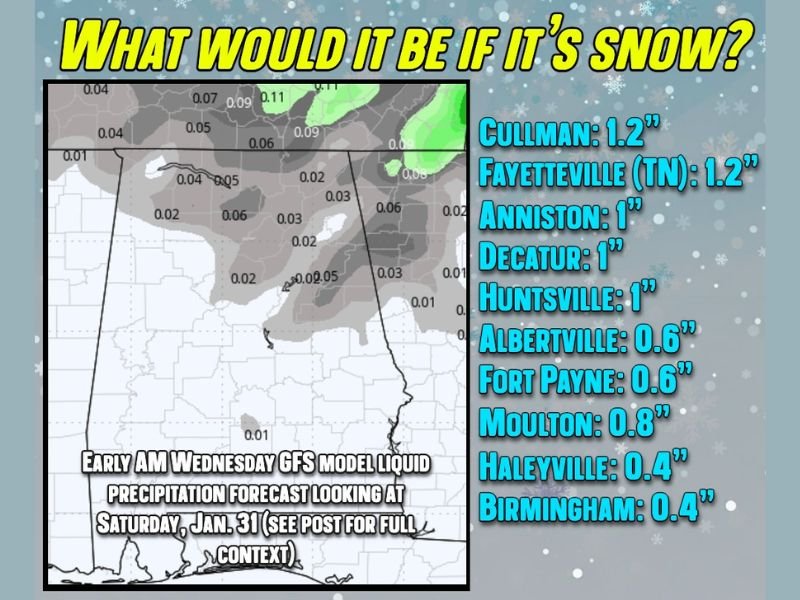
The GFS model shows small amounts of liquid precipitation across parts of northern Alabama. Under normal conditions, this would simply fall as rain. However, with Arctic air firmly in place, that liquid could theoretically convert to dry, fluffy snow.
Using a conservative 20:1 snow-to-liquid ratio, the GFS output translates into very light snow amounts if everything aligns perfectly. This method reflects how snow behaves in extremely cold air masses, similar to historic cold events in the region.
In contrast, the European model takes a far more restrained approach. It shows little to no precipitation for central Alabama, including Birmingham and Cullman, and only suggests a light dusting potential in the mountains of northeast Alabama. This model significantly reduces confidence in widespread snow.
Areas With the Best Snow Potential
If snow occurs, the most favorable locations are north and northeast Alabama, particularly near higher elevations. Based on model conversion estimates, potential amounts remain modest:
Cullman around 1 inch
Huntsville near 1 inch
Decatur near 1 inch
Albertville and Fort Payne around half an inch
Birmingham closer to a few tenths of an inch, if any
These values represent best-case scenarios, not guaranteed outcomes.
Why Confidence Remains Low
Snow in Alabama requires a very precise setup. While the incoming Arctic air is more than cold enough, moisture availability remains the limiting factor. Even a strong upper-air disturbance cannot produce snow without sufficient moisture to work with.
Forecasters note that while flurries or brief snow showers are possible, especially late Saturday into early Sunday, the most likely outcome remains cold air followed by disappointment, a familiar pattern for Alabama winter weather.
What Residents Should Expect
The bottom line is that extreme cold is the certainty, while snow remains the wildcard. Residents should prepare for freezing temperatures, protect pipes, pets, and plants, and avoid focusing too heavily on snow totals that may never materialize.
Surprise pockets of 1–2 inches are not impossible, but this setup does not support a major snowstorm. Travel impacts, if any, would be limited and localized.
As Alabama continues through one of its colder winter stretches in recent years, staying weather-aware remains important. For continued coverage of national and regional weather developments and their broader impacts, visit NapervilleLocal.com for ongoing updates.

I’ve lived in Naperville long enough to see how quickly our community changes — from new developments downtown to sudden shifts in our Midwest weather. Reporting on Naperville news and daily forecasts gives me the chance to keep neighbors informed about what really matters. My goal is simple: deliver clear, timely updates so you always know what’s happening in our city and what to expect from the skies above.