
Eastern North Carolina and Virginia Coast Face Rare Blizzard Threat as Bomb Cyclone Signals Extreme Snow, Wind, and Thundersnow
CAROLINA COAST — Confidence is increasing that a powerful winter storm may deliver rare blizzard conditions to parts of eastern North Carolina and the Virginia coastline this weekend as a rapidly intensifying offshore system develops into a bomb cyclone.
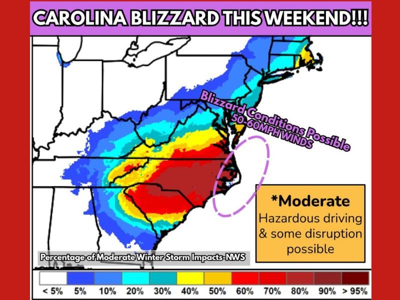
Forecast data highlights an unusually dangerous setup for the Carolina coastline, where snowfall rates could exceed 2 inches per hour, combined with 50–60 mph wind gusts and the potential for thundersnow. These conditions are considered extremely rare for coastal areas of the Carolinas, where winter storms typically struggle to maintain intensity.
Why This Storm Is Different
The developing system is expected to strengthen rapidly offshore, a process known as bombogenesis, which allows the storm to intensify while pulling cold air and moisture together along the coast. This combination creates the potential for heavy, wind-driven snow rather than a typical cold-rain or mixed event.
Unlike inland winter storms, coastal blizzards rely on precise storm placement. Current data shows the storm track favoring eastern North Carolina into southeastern Virginia, placing these areas in the zone most likely to experience blizzard-level impacts.
Areas Most at Risk
The highest risk zone includes eastern North Carolina, particularly coastal and near-coastal counties, extending northward into the Virginia Tidewater region. These areas show the greatest overlap of heavy snow potential and strong winds.
Snowfall rates above 2 inches per hour could lead to near-whiteout conditions, while powerful wind gusts may cause blowing and drifting snow, making travel extremely hazardous or impossible for periods of time.
Wind, Power, and Travel Concerns
Wind gusts reaching 50–60 mph raise concerns for downed trees, power outages, and structural damage, especially in coastal communities not accustomed to blizzard conditions. Hazardous driving is expected, with some disruption likely even in areas that fall just outside the core snow band.
If current trends continue, Blizzard Watches or Warnings may be required as the event draws closer, signaling a high-impact and potentially dangerous storm for the region.
What Residents Should Prepare For
Residents along the Carolina coast and into southeastern Virginia should prepare for rapidly deteriorating conditions this weekend. Travel may become impossible during peak snowfall and wind, and power interruptions are a growing concern.
Because coastal blizzard setups are rare and highly sensitive to storm track changes, continued monitoring of updates is critical. Even small shifts could significantly change impact zones.
As this developing storm moves toward a critical forecast window, it has the potential to become one of the more significant winter weather events ever observed along parts of the Carolina coastline. For continued coverage of major national weather events and their broader impacts, visit NapervilleLocal.com for ongoing updates.

I’ve lived in Naperville long enough to see how quickly our community changes — from new developments downtown to sudden shifts in our Midwest weather. Reporting on Naperville news and daily forecasts gives me the chance to keep neighbors informed about what really matters. My goal is simple: deliver clear, timely updates so you always know what’s happening in our city and what to expect from the skies above.