
Ohio Faces Elevated Heavy Snow Threat Between February 5–9 as Arctic Cold Locks In Across the Region
OHIO — Forecasters are increasingly concerned about a potentially active winter stretch between February 5 and February 9, with parts of Ohio now under a medium risk for heavy snow as a deep Arctic air mass remains firmly entrenched across the region.
After a quieter period dominated mainly by cold temperatures, the broader winter pattern is turning more active. Meteorologists say the atmosphere is now aligning in a way that could support multiple snow-producing systems, some of which may bring significant accumulations.
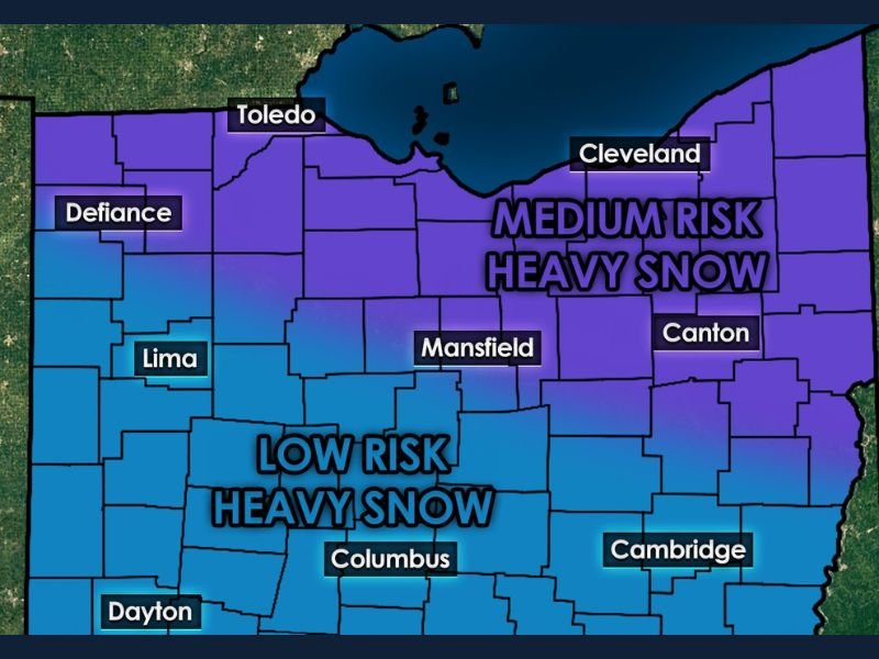
Medium Risk Zone Highlights Northern and Northeast Ohio
Forecast risk maps show a medium risk for heavy snow focused across northern and northeastern Ohio, including areas near:
- Cleveland
- Toledo
- Mansfield
- Canton
In these areas, confidence is growing that at least one system during the February 5–9 window could produce 6 inches of snow or more, which meets the threshold for heavy snow in this forecast.
Lower Risk Extends Across Central and Southern Ohio
A low risk for heavy snow stretches farther south and west, covering much of:
- Columbus
- Dayton
- Lima
- Cambridge
While heavy snow is less likely in these areas, forecasters caution that changing storm tracks could still bring impactful snowfall, especially if individual systems trend stronger or shift north or south.
Arctic Air Mass Sets the Stage
A stubborn Arctic air mass is expected to remain locked in place through at least mid-February, creating ideal conditions for snow whenever moisture is introduced. With cold air already in place, even modest storm systems could generate efficient snowfall.
Meteorologists note that confidence is slowly increasing that this could become a high-impact period for parts of the region, particularly where heavier snow bands set up.
Why This Period Is Being Closely Watched
This setup contains several classic ingredients for significant winter weather:
- Persistent Arctic cold
- Increasing storm activity
- Multiple opportunities for snow rather than a single event
Rather than one major storm, forecasters say the risk lies in repeated snow chances that could compound impacts over several days.
Bottom Line
Ohio is entering a potentially active and impactful winter stretch between February 5 and February 9, with northern and northeastern parts of the state facing the highest risk for heavy snow. While exact storm tracks and totals remain uncertain, the overall pattern strongly favors continued winter weather.
Residents across Ohio should monitor forecasts closely as confidence increases and details become clearer in the days ahead. For continued coverage of developing winter threats across the Midwest and beyond, stay with NapervilleLocal.com.

I’ve lived in Naperville long enough to see how quickly our community changes — from new developments downtown to sudden shifts in our Midwest weather. Reporting on Naperville news and daily forecasts gives me the chance to keep neighbors informed about what really matters. My goal is simple: deliver clear, timely updates so you always know what’s happening in our city and what to expect from the skies above.