
Western Carolinas Face High-Confidence Snow Threat as Models Signal Widespread Accumulations in Early February
NORTH CAROLINA & SOUTH CAROLINA — Confidence is rapidly increasing that parts of the western Carolinas could see a notable snow event in early February, as advanced ensemble guidance signals a strong probability of widespread accumulation across the region.
Meteorologists analyzing the latest European ensemble data say the signal is no longer speculative. Instead, it reflects a high-confidence setup supported by dozens of model solutions pointing toward impactful winter weather.
Ensemble Data Shows Strong Agreement
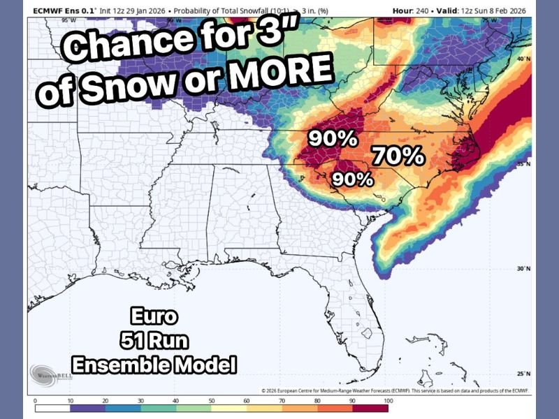
The latest European ensemble model, which blends 51 individual model runs, indicates a 90% chance of at least 3 inches of snow across large portions of the western Carolinas. This level of agreement is considered significant, especially compared to single-run forecast models that can fluctuate from update to update.
Forecasters emphasize that ensemble guidance is a more reliable way to assess risk, and in this case, nearly all signals are aligned toward accumulating snowfall.
Higher Totals Becoming More Likely
Beyond the 3-inch threshold, current projections suggest snow totals in the 4 to 8 inch range are increasingly plausible in the most favored areas. While exact placement of heavier bands is still being refined, confidence continues to rise that this will be more than a minor or nuisance event.
The strongest probabilities are focused across western North Carolina and adjacent areas of upstate South Carolina, where cold air and storm dynamics are expected to overlap most efficiently.
Why This Signal Matters
What makes this setup stand out is not just the snow potential, but the consistency across model guidance. Every major piece of data continues to reinforce the same message: the environment is supportive of a meaningful winter weather event, and forecast confidence is increasing rather than decreasing as the window approaches.
Meteorologists note that when ensemble probabilities climb this high days in advance, the risk of a disruptive outcome becomes harder to ignore.
Forecast Still Being Refined
While the overall message is clear, forecasters stress that details such as exact snowfall amounts and precise impact zones will continue to evolve. Small shifts in storm track or temperature profiles could still influence who sees the highest totals.
Even so, the broader takeaway remains unchanged: the western Carolinas are entering a high-risk period for accumulating snow, and the signal is strengthening with each update.
Residents across the region should stay alert as confidence continues to rise and forecast details become clearer. For continued coverage of major winter weather developments across the U.S., follow updates on NapervilleLocal.com.

I’ve lived in Naperville long enough to see how quickly our community changes — from new developments downtown to sudden shifts in our Midwest weather. Reporting on Naperville news and daily forecasts gives me the chance to keep neighbors informed about what really matters. My goal is simple: deliver clear, timely updates so you always know what’s happening in our city and what to expect from the skies above.