
Winter Storm Warning Expands Across Georgia, North Carolina, and South Carolina as Heavy Snow and Dangerous Travel Loom
Georgia, North Carolina, South Carolina — A rapidly intensifying winter storm has prompted an expanded Winter Storm Warning across northeast Georgia, the foothills and Piedmont of North Carolina, and upstate South Carolina, with forecasters warning of heavy snowfall, strong winds, and dangerous travel conditions through early Sunday morning.
According to the latest warning information, snow accumulations of 4 to 7 inches are expected, with gusty winds up to 30 miles per hour worsening visibility and road conditions. Officials caution that travel may become hazardous or even impossible in some areas, particularly during the Friday evening commute.
Areas Under the Winter Storm Warning
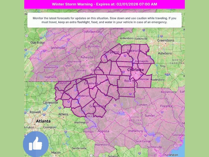
The Winter Storm Warning covers a large and heavily populated portion of the southern Appalachians and surrounding regions. Impacted areas include northeast Georgia, much of western and central North Carolina, and upstate South Carolina.
Major cities and surrounding communities within the warning area include Asheville, Charlotte, Morganton, Statesville, Greenville, Anderson, Greenwood, and nearby foothill and Piedmont counties. The warning area extends across multiple state lines, increasing the likelihood of widespread regional disruptions.
Snowfall and Wind Forecast
Forecasters expect widespread heavy snow, with totals ranging from 4 to 7 inches across much of the warned region. In higher elevations and persistent snow bands, locally higher totals cannot be ruled out.
Strong winds gusting up to 30 mph may lead to blowing snow, reducing visibility on roadways and increasing the risk of isolated power outages, especially where snow accumulates on trees and power lines.
Travel Conditions Expected to Deteriorate Quickly
Road conditions are expected to worsen rapidly once snowfall intensifies. Officials warn that roads may become impassable, particularly secondary routes, bridges, and mountain roadways.
Travel impacts are expected to be most severe during the Friday evening commute, when snowfall rates may increase quickly. Motorists are urged to avoid unnecessary travel and prepare for delays if travel cannot be postponed.
Power Outage and Infrastructure Concerns
The combination of heavy snow and gusty winds raises the risk of isolated power outages, especially in areas with dense tree cover or aging infrastructure. Emergency crews across the region are preparing for weather-related service disruptions that may persist even after snowfall ends.
Residents are encouraged to prepare for the possibility of limited access to emergency services during peak storm conditions.
What Residents Should Do Now
Officials urge residents across the warning area to monitor forecast updates closely and take precautionary measures ahead of the storm. Recommended actions include charging electronic devices, keeping emergency supplies on hand, and avoiding travel once conditions deteriorate.
Those who must travel are advised to keep extra food, water, and a flashlight in their vehicle in case of emergencies.
As this winter storm continues to evolve, additional updates or extensions to the warning remain possible. NapervilleLocal.com will continue monitoring this significant winter weather event and its broader impacts across the Southeast, including potential regional travel and supply disruptions.

I’ve lived in Naperville long enough to see how quickly our community changes — from new developments downtown to sudden shifts in our Midwest weather. Reporting on Naperville news and daily forecasts gives me the chance to keep neighbors informed about what really matters. My goal is simple: deliver clear, timely updates so you always know what’s happening in our city and what to expect from the skies above.