
East Coast Winter Storm Deepens Rapidly Offshore as Hurricane-Strength Low Brings Near-Blizzard Threat to North Carolina and Virginia Coast
North Carolina and Virginia — A powerful East Coast winter storm is intensifying rapidly offshore as a deepening low-pressure system reaches hurricane-strength pressure levels, setting the stage for dangerous winds, heavy snow, and near-blizzard conditions, particularly along eastern North Carolina and coastal Virginia.
Forecast data shows the storm strengthening dramatically as it moves northeast just offshore, close enough to deliver significant impacts on land. Meteorologists warn that the system’s pressure could drop into the upper 960s to near 970 millibars, a range more commonly associated with strong tropical systems, making this one of the most intense winter storms of the season for the region.
Deepening Low Pressure Driving Extreme Conditions
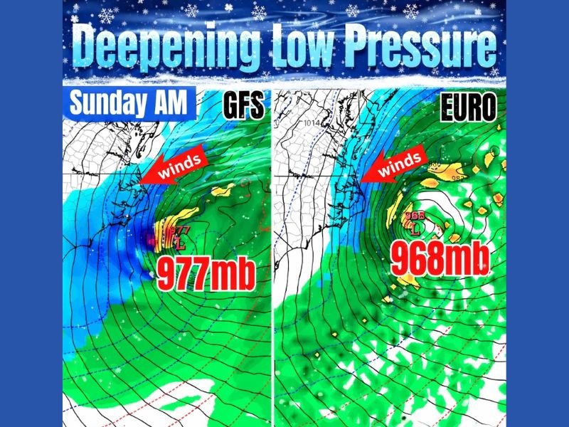
Model guidance from both the GFS and EURO highlights a rapidly intensifying low centered just off the Mid-Atlantic coast Sunday morning. Pressure values between 977 mb and as low as 968 mb indicate an exceptionally strong storm capable of producing widespread damaging winds along the coastline.
As the low deepens offshore, strong pressure gradients are expected to funnel powerful onshore winds toward the coast before the system lifts northeast. These winds will play a critical role in worsening snow impacts and reducing visibility across eastern portions of North Carolina and Virginia.
Near-Blizzard Conditions Possible in Eastern NC and VA
The National Weather Service has already begun highlighting the potential for near-blizzard conditions, especially in eastern North Carolina and eastern Virginia, where heavy snowfall combines with intense winds.
Snowfall rates may increase rapidly as the storm reaches peak intensity, and when paired with strong winds, conditions could deteriorate quickly. Visibility reductions, blowing snow, and drifting are likely, making travel extremely dangerous or impossible in some areas.
Outer Banks and Coastal Impacts Likely
The Outer Banks of North Carolina are expected to be particularly vulnerable due to their exposure to onshore winds. Coastal impacts may include hazardous travel, rapidly changing conditions, and potential infrastructure stress as the storm remains close enough offshore to be fully felt on land.
While the low is forecast to track northeast and remain offshore, its proximity means coastal communities will still experience the brunt of its strongest winds and snowfall bands.
Travel and Infrastructure Concerns Across the Region
Road conditions across eastern North Carolina and Virginia are expected to worsen significantly as snow and wind intensify. Bridges, causeways, and coastal highways may become especially dangerous due to blowing snow and strong crosswinds.
Power outages are also possible as intense winds interact with snow-laden trees and power lines. Emergency managers are urging residents to prepare for the possibility of extended disruptions, especially in coastal and low-lying communities.
Why Meteorologists Are Watching This Storm Closely
What makes this system especially notable is the rate of intensification combined with its near-perfect offshore placement. The storm is close enough to bring severe impacts onshore but far enough offshore to maintain its strongest pressure gradient and wind field.
This setup increases the risk of prolonged hazardous conditions even after snowfall tapers, as strong winds may persist while the storm slowly pulls away to the northeast.
As this high-impact winter storm continues to evolve, NapervilleLocal.com will keep monitoring developments across the East Coast, including potential travel disruptions and broader regional effects that may ripple beyond the immediate impact zone.

I’ve lived in Naperville long enough to see how quickly our community changes — from new developments downtown to sudden shifts in our Midwest weather. Reporting on Naperville news and daily forecasts gives me the chance to keep neighbors informed about what really matters. My goal is simple: deliver clear, timely updates so you always know what’s happening in our city and what to expect from the skies above.