
Heavy Snow Breaks Out Late Across Southeast North Carolina as Radar Confirms Intense Bands Over Wilmington and Surrounding Counties
SOUTHEAST NORTH CAROLINA — Snow began falling across large portions of Brunswick, New Hanover, Columbus, Bladen, Pender, and Robeson counties late this evening, with radar imagery confirming intensifying snow bands moving inland as temperatures dropped into the upper teens.
The update, issued around 10:38 p.m., confirms that snow is actively coming down across the region, with periods of heavier snowfall possible overnight, especially where stronger bands persist.
Radar Shows Snow Intensifying Near Wilmington and Inland Communities
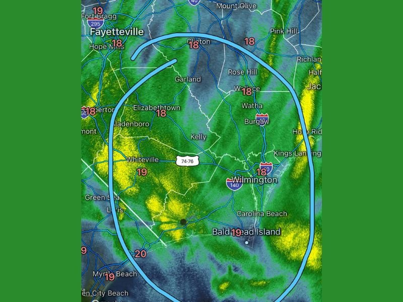
Radar imagery highlights a broad, curved band of precipitation stretching across Wilmington, Carolina Beach, Bald Head Island, Burgaw, Whiteville, Elizabethtown, Garland, Kelly, Rose Hill, and Watha. Surface temperatures across much of the region are hovering between 18 and 20 degrees, cold enough to support accumulating snow.
Yellow and green returns on radar indicate moderate to occasionally heavy snowfall, suggesting that some areas could see rapid changes in road conditions within short distances.
Snowfall Expands Across Coastal and Inland Counties
Communities across Brunswick and New Hanover counties are reporting steady snowfall, while inland areas of Columbus, Bladen, Pender, and Robeson counties are also seeing snow intensify. The setup favors uneven snowfall totals, with some locations picking up significantly more snow than nearby towns depending on band placement. Forecasters caution that snowfall rates may briefly increase under heavier bands, reducing visibility and making travel increasingly dangerous.
Travel Conditions Expected to Deteriorate Overnight
With temperatures firmly below freezing, any snow falling is expected to stick quickly to roads, bridges, and overpasses. Emergency officials urge residents to avoid unnecessary travel, especially during heavier bursts of snow. Drivers already on the roads are advised to slow down, increase following distance, and remain alert for rapidly changing conditions.
What Happens Next
Snow is expected to continue through the late evening and overnight hours, with on-and-off heavier periods possible. While exact totals will vary, the combination of cold temperatures and persistent snowfall raises concerns for hazardous travel and localized impacts through the night. Residents are encouraged to stay indoors if possible and monitor local alerts as conditions evolve.
Are you seeing snow where you live in southeast North Carolina? Share your reports and stay with NapervilleLocal.com for continued overnight updates and verified weather coverage as this winter event unfolds.

I’ve lived in Naperville long enough to see how quickly our community changes — from new developments downtown to sudden shifts in our Midwest weather. Reporting on Naperville news and daily forecasts gives me the chance to keep neighbors informed about what really matters. My goal is simple: deliver clear, timely updates so you always know what’s happening in our city and what to expect from the skies above.