
Hurricane-Strength Bomb Cyclone Explodes Off North Carolina Coast as Pressure Plunges Over 30 Millibars in 24 Hours
UNITED STATES — A powerful winter storm off the coast of North Carolina has officially intensified into a bomb cyclone, rapidly strengthening as atmospheric pressure dropped more than 30 millibars within a 24-hour period, a hallmark of extreme storm development.
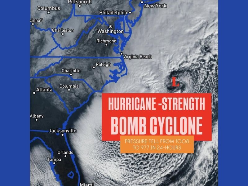
Satellite imagery from this morning shows a tightly wound system over the western Atlantic, with widespread cloud cover and snow visible across large portions of the Southeast as the storm continues to organize offshore.
What Makes This Storm a Bomb Cyclone
Meteorologically, a bomb cyclone occurs when a storm’s central pressure falls at least 24 millibars in 24 hours. In this case, the storm exceeded that threshold, with pressure falling from approximately 1008 millibars to near 977 millibars, placing it firmly in the category of a rapidly intensifying system.
This rate of strengthening rivals that of hurricanes, which is why bomb cyclones are often described as having hurricane-strength characteristics, especially in terms of wind and pressure gradients.
Satellite View Shows Massive Storm Structure
The satellite image highlights a well-defined low-pressure center east of the Carolinas, marked clearly offshore of North Carolina. Thick cloud bands wrap tightly around the storm, extending inland across the Southeast, where snow cover is visible beneath the cloud deck.
Cities visible beneath the system’s influence include Raleigh, Charlotte, Columbia, Atlanta, Richmond, Virginia Beach, Washington, Philadelphia, and New York, showing just how expansive the storm’s reach has become.
Snow and Severe Winter Impacts Across the Southeast
While the storm’s center remains offshore, its influence stretches far inland. Snow visible from satellite imagery confirms that winter weather has spread across the Southeast, an unusual but increasingly observed pattern during strong Arctic outbreaks paired with explosive cyclogenesis offshore.
Such systems are known to produce:
- Strong, damaging winds along the coast
- Heavy snowfall inland
- Rapidly changing conditions over short periods
Even as the storm pulls away, lingering impacts can continue for many hours due to its size and intensity.
Why This Storm Stands Out
This is not a typical coastal low. The combination of extreme pressure falls, a tight circulation, and snow visible across multiple states makes this bomb cyclone a standout event in this winter season. Storms of this magnitude underscore how quickly conditions can escalate when Arctic air interacts with warm Atlantic moisture.
As this system continues to evolve offshore, NapervilleLocal.com will keep tracking major winter storms and national weather events, explaining what they mean and why they matter as conditions develop.

I’ve lived in Naperville long enough to see how quickly our community changes — from new developments downtown to sudden shifts in our Midwest weather. Reporting on Naperville news and daily forecasts gives me the chance to keep neighbors informed about what really matters. My goal is simple: deliver clear, timely updates so you always know what’s happening in our city and what to expect from the skies above.