
Michigan, Ohio and Pennsylvania See 70+ Mile Crack Split Lake Erie Ice as the Lake Nears Full Freeze
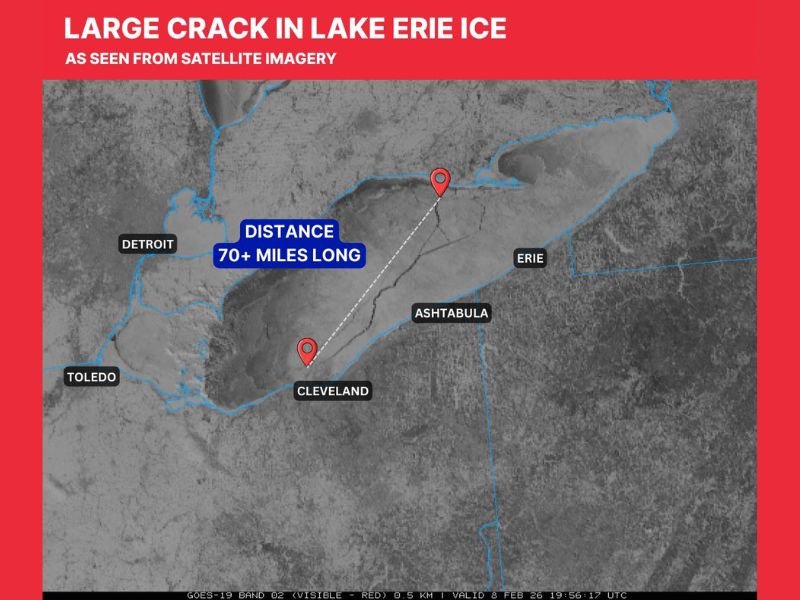
UNITED STATES — A massive crack stretching more than 70 miles has opened up in the ice covering Lake Erie, showing up clearly on GOES-19 satellite imagery as the lake nears a stage where it could become nearly completely iced over. The feature was highlighted in an update timestamped 7:25 p.m. on Feb. 8, 2026, and the map labels place the crack across the Lake Erie corridor between key shoreline areas in Michigan, Ohio, and Pennsylvania.
Where the 70+ mile Lake Erie ice crack is showing up
The graphic identifies major points around the lake—Detroit and Toledo on the western side, Cleveland and Ashtabula along Ohio’s shoreline, and Erie on the eastern side—illustrating just how wide-ranging the fracture is across the lake’s ice sheet.
What stands out in the satellite view is how sharply defined the crack appears compared to surrounding ice, with a measurement callout indicating a “70+ miles long” distance across the fracture line.
Why cracks like this happen when lakes start freezing over
Large ice cracks on big lakes can form for several reasons, especially when a lake is approaching broader, more continuous ice coverage:
Temperature swings can cause ice to expand and contract, creating stress lines that suddenly release as fractures. Wind can also shift or compress ice fields, forcing plates of ice to push, buckle, or pull apart. On large bodies of water like Lake Erie, changing currents and wave action beneath thinner sections can also contribute to breaks—especially during periods of transition when ice is spreading quickly.
The update notes that these cracks “happen from time to time,” but what made this one notable is how clearly it could be seen from space.
Why this matters for safety along the Great Lakes
A crack like this is a reminder that ice conditions can change fast—even when a lake looks solid from shore. Wide fractures can create open water leads or weak transition zones that are hard to spot at ground level, particularly during low light, snow cover, or windy conditions.
For anyone near Lake Erie, the key message is simple: don’t assume continuous ice equals safe ice. Even areas that were frozen earlier in the day can shift or fracture later, especially during active weather patterns or temperature changes.
What Naperville-area residents should take from this
While this specific crack is on Lake Erie, the broader takeaway applies across the Great Lakes region, including Lake Michigan: mid-winter ice can be unpredictable, especially during freeze-up phases or after sudden warmups and cold snaps. If you’re traveling east or have family near Michigan, Ohio, or Pennsylvania shorelines, this is the kind of development that local officials typically want residents to take seriously—particularly if people are ice fishing, walking, or attempting snowmobile/ATV travel on frozen surfaces.
Bottom line
The satellite imagery shows a 70+ mile-long fracture across Lake Erie’s ice spanning the Great Lakes corridor touching Michigan, Ohio, and Pennsylvania, as the lake heads toward near-total ice coverage. It’s visually impressive—but it’s also a clear reminder that big-lake ice is dynamic, and cracks can form quickly even during periods of intense cold.
If you’ve noticed changing ice conditions or unusual freeze patterns near your area this winter, share what you’re seeing and follow more regional updates at NapervilleLocal.com.

I’ve lived in Naperville long enough to see how quickly our community changes — from new developments downtown to sudden shifts in our Midwest weather. Reporting on Naperville news and daily forecasts gives me the chance to keep neighbors informed about what really matters. My goal is simple: deliver clear, timely updates so you always know what’s happening in our city and what to expect from the skies above.