
United States Warm-Up Pattern Shows 10–25° Above-Average Temperatures, While Ohio Valley and Northeast Stay Colder
UNITED STATES — A quick but intense temperature swing is unfolding across the country as a short-lived warm-up pushes into large portions of the central and western United States, while colder-than-normal air remains entrenched across the Ohio Valley and the Northeast, according to temperature anomaly guidance.
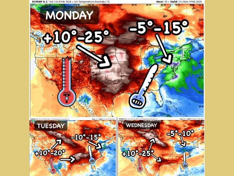
Forecast model data shows this warm surge could drive temperatures 10 to 25 degrees above average across a broad region early in the week. However, the pattern is not expected to last, with the warmest air retreating later in the week and into the weekend.
Warm surge expected across much of the central and western U.S.
Temperature anomaly maps for early to midweek indicate a notable warm push spreading across much of the central Plains, Rockies, and parts of the western United States. In these areas, above-average warmth is expected to dominate for a short period, offering a break from recent cold conditions.
While the anomalies appear dramatic on the maps, forecasters note that prolonged heat waves are rare in February, and this event is better described as a brief but noticeable warm spell rather than a sustained shift toward spring.
Ohio Valley and Northeast remain on the colder side
In contrast, the Ohio Valley and much of the Northeast are forecast to remain under cooler air during the same time frame. Anomalies in these regions range from 5 to 15 degrees below average, especially during the early part of the week.
Although some moderation is expected later in the week, colder air is slower to retreat from these regions, reinforcing a sharp temperature divide across the country.
Midweek transition brings uncertainty
By Tuesday and Wednesday, the overall pattern begins to shift, with model guidance showing fluctuations in the placement of warmer and colder air. These changes depend heavily on storm track positioning, which could cause rapid temperature swings in areas near the boundary between the warm and cold air masses.
As a result, conditions may change quickly, with some regions experiencing brief warmups followed by renewed cooling.
Bottom line
The current setup points to a fast-moving warm-up across large portions of the United States, contrasted by persistent cold across the Ohio Valley and Northeast. While the warm surge may feel significant, it is expected to be temporary, with temperatures trending back closer to seasonal norms as the week progresses.
This pattern highlights the volatile nature of late-winter weather, where sharp temperature swings remain common heading toward the second half of February.
If you’ve been tracking shifting weather patterns or noticing unusual temperature swings where you live, share your thoughts with us. For more updates and regional weather coverage as conditions evolve across the U.S., visit NapervilleLocal.com and join the conversation.

I’ve lived in Naperville long enough to see how quickly our community changes — from new developments downtown to sudden shifts in our Midwest weather. Reporting on Naperville news and daily forecasts gives me the chance to keep neighbors informed about what really matters. My goal is simple: deliver clear, timely updates so you always know what’s happening in our city and what to expect from the skies above.