
Pennsylvania Braces for a Frigid Overnight Plunge as Clear Skies Drive “Radiational Cooling” Into Monday Morning
PENNSYLVANIA — A quiet-looking night is expected to turn dangerously cold across much of the state, with forecasters warning that the biggest story won’t be wind chill — it will be the actual air temperature dropping fast under clear skies and fading winds.
Radiational cooling is expected to do the damage overnight, a process where heat escapes rapidly from the ground after sunset when skies are clear and winds are light. Forecasters say this can cause temperatures to fall quicker than people expect — and the effect can be even stronger in areas with deeper snowpack.
Coldest Temperatures Expected Across Western and Northern Pennsylvania
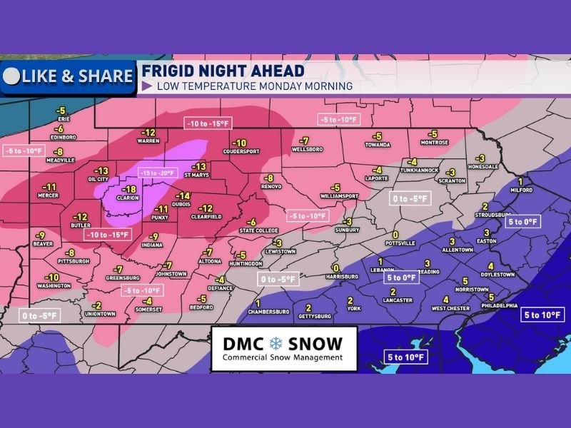
Forecast guidance shows the sharpest drop lining up across the north and west, where many communities could dip below zero by daybreak Monday. The coldest pocket appears centered around parts of northwestern and north-central Pennsylvania, where readings as low as -15°F to -20°F are possible in the coldest spots.
Several locations shown in the forecast map fall into the single digits below zero, including areas near Clarion (-18°F), Dubois (-14°F), St. Marys (-13°F), Oil City (-13°F), Warren (-12°F), Clearfield (-12°F), and Butler (-12°F). Other cold readings include Pittsburgh (-8°F), Johnstown (-7°F), Altoona (-7°F), and State College (-6°F).
Eastern Pennsylvania May Stay Slightly “Less Extreme,” But Still Bitter
Forecasters note eastern Pennsylvania could avoid the worst of the plunge if a light breeze holds overnight, limiting how low temperatures fall. Even so, conditions are still expected to be harsh, with readings near or below zero in several areas.
The map shows Harrisburg around 1°F, Reading near 3°F, Allentown near 3°F, and Philadelphia near 5°F by Monday morning — still cold enough to create hazardous conditions for anyone outdoors for long periods.
How Fast It Warms Up Monday — And What Comes Next
The cold won’t last all day. Forecast messaging indicates temperatures should rebound into the 20s by late morning and afternoon Monday, especially as daytime sun helps slow the cooling cycle.
A broader warming trend is expected Tuesday, with highs returning to the 30s and 40s across much of Pennsylvania — and a chance that parts of far southwestern Pennsylvania could briefly flirt with a 50-degree high.
If you’ll be outside overnight or early Monday, plan for the coldest stretch to hit close to daybreak — and bundle up accordingly. NapervilleLocal.com will continue tracking major weather impacts nationwide — share what you’re seeing where you live, and keep checking NapervilleLocal.com for more updates.

I’ve lived in Naperville long enough to see how quickly our community changes — from new developments downtown to sudden shifts in our Midwest weather. Reporting on Naperville news and daily forecasts gives me the chance to keep neighbors informed about what really matters. My goal is simple: deliver clear, timely updates so you always know what’s happening in our city and what to expect from the skies above.