
New Forecast Models Signal Possible Arctic Air Push After February 20 as Polar Vortex Disruption Spreads Across Multiple U.S. States
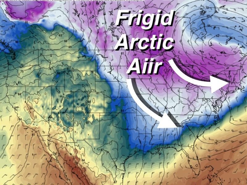
UNITED STATES — Newly released forecast data indicates a possible return of colder Arctic air after February 20, linked to a disruption in the polar vortex. The information does not confirm exact impacts or temperatures, but the map clearly shows a large Arctic air mass positioned over wide areas of the central and eastern United States, signaling a renewed cold pattern may develop.
The data highlights a southward dip in the upper-level jet stream, allowing cold Arctic air to extend farther south than usual. The accompanying text emphasizes uncertainty, stating that outcomes remain possibility-based, not guaranteed.
States Where Arctic Air Is Visibly Positioned on the Map
Based strictly on map shading and placement, the Arctic air mass is shown covering or overlapping parts of the following states:
Upper Midwest and Northern Plains
- Montana
- North Dakota
- South Dakota
- Minnesota
- Wisconsin
- Iowa
- Nebraska
Central Plains and Midwest
- Kansas
- Missouri
- Illinois
- Indiana
- Michigan
Ohio Valley and Southern Edge
- Ohio
- Kentucky (mainly northern areas)
- Tennessee (northern portion)
- Arkansas (northern portion)
Northeast and Mid-Atlantic
- Pennsylvania
- New York
- West Virginia
- Virginia
- Maryland
- New Jersey
- Portions of New England
The core of the coldest air appears centered over the Upper Midwest and Great Lakes, while southern states lie closer to the edge of the cold air boundary.
What the Polar Vortex Disruption Suggests
The polar vortex is a large circulation of extremely cold air that typically remains near the Arctic. When disrupted, portions of this cold air can shift southward into the United States.
The data suggests a disturbed or displaced vortex, not a complete collapse. This distinction indicates the potential for a cold intrusion, but not necessarily a prolonged or extreme event.
The jet stream pattern shown supports this scenario, with Arctic air able to move south through the central part of the country.
Timing Window Shown in the Data
The only timing reference provided states:
- “After the 20th we get cold again”
No specific dates, duration, or temperature values are included. As a result, the timeframe should be interpreted as a general late-February window, not a fixed forecast.
Why This Pattern Is Being Watched
Late-winter Arctic air intrusions can still influence travel, energy demand, and daily conditions across large areas of the country. While this data does not confirm impacts, it identifies a pattern worth monitoring as February progresses.
Further clarity will come as newer model runs refine the position and strength of the Arctic air mass. For continued data-driven weather coverage and responsible reporting without speculation, follow updates on NapervilleLocal.com.

I’ve lived in Naperville long enough to see how quickly our community changes — from new developments downtown to sudden shifts in our Midwest weather. Reporting on Naperville news and daily forecasts gives me the chance to keep neighbors informed about what really matters. My goal is simple: deliver clear, timely updates so you always know what’s happening in our city and what to expect from the skies above.