
South Carolina’s Historic Blizzard of 1973 Buried Pee Dee, Midlands, and Coast Under Nearly Two Feet of Snow
SOUTH CAROLINA — Fifty-three years ago today, one of South Carolina’s most significant winter storms was unfolding, as the Blizzard of 1973 delivered extraordinary snowfall across large portions of the state. The storm, which began the night of February 8 and lasted through February 11, produced nearly two feet of snow in parts of the Pee Dee and Midlands, with double-digit snowfall even reaching the coast.
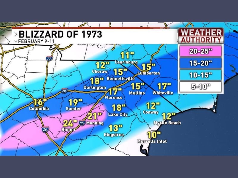
According to the data shown, snow fell steadily for two full days, creating conditions rarely seen in South Carolina’s recorded weather history.
Snowfall Totals Show Widespread and Extreme Impact
The snowfall map from the Blizzard of 1973 highlights how extensive and intense the storm was across the state. Several inland communities recorded snowfall amounts that rival major northern snowstorms.
Notable totals shown on the map include:
- Manning: 24 inches
- Rimini: 24 inches
- Lake City: 18 inches
- Darlington: 18 inches
- Florence: 17 inches
- Bennettsville: 15 inches
- Sumter: 19 inches
- Columbia: 16 inches
These totals confirm that large portions of central and northeastern South Carolina were buried under more than a foot of snow, an extremely rare occurrence for the region.
Coastal Areas Also Saw Unusual Snow Accumulation
What makes the Blizzard of 1973 especially remarkable is that significant snow reached South Carolina’s coastline, an event that remains uncommon even decades later.
Coastal snowfall amounts shown include:
- Myrtle Beach: 12 inches
- Conway: 12 inches
- Murrells Inlet: 10 inches
The presence of a full foot of snow along the beaches underscores the historic nature of the storm, as coastal South Carolina typically experiences little to no measurable snowfall during winter.
Pee Dee and Midlands Hit Hardest
The map indicates the heaviest snowfall corridor stretched across the Pee Dee region into the Midlands, where totals frequently exceeded 15 to 20 inches. Areas near Interstate 95 and surrounding rural communities were among the hardest hit, with prolonged snowfall compounding travel disruptions and isolation.
The storm’s duration and intensity made it one of the most impactful winter weather events in state history.
Why the Blizzard of 1973 Still Stands Out
South Carolina averages only occasional light winter precipitation, making the Blizzard of 1973 an outlier in both scale and severity. The combination of:
- Multi-day snowfall
- Near-record accumulations
- Snow reaching inland and coastal areas
has kept the storm firmly embedded in the state’s weather memory more than five decades later.
A Storm Still Remembered Generations Later
More than 50 years later, the Blizzard of 1973 remains a benchmark event for winter weather across South Carolina. Many residents still recall roads buried under snow, daily routines brought to a halt, and landscapes transformed by a storm unlike anything seen before or since.
For continued coverage of historic weather events, climate patterns, and notable moments in regional weather history, follow updates on NapervilleLocal.com.

I’ve lived in Naperville long enough to see how quickly our community changes — from new developments downtown to sudden shifts in our Midwest weather. Reporting on Naperville news and daily forecasts gives me the chance to keep neighbors informed about what really matters. My goal is simple: deliver clear, timely updates so you always know what’s happening in our city and what to expect from the skies above.