
Florida Sees Sharp Temperature Split as Cold Morning Starts in the 30s and 40s Before Afternoon Warmth Near 80 Degrees
FLORIDA — Florida experienced a striking temperature contrast Tuesday, starting the morning with chilly readings in the 30s and 40s across many inland and northern communities before a much warmer afternoon expected to reach the 70s to near 80 degrees. The early-day cold prompted the need for heavy coats in some areas, despite the rapid warm-up later in the day.
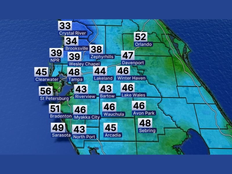
The temperature map reflects conditions at 6:00 a.m. Tuesday, highlighting how unusually cool the morning was for parts of the state.
Morning Temperatures Show Widespread Chill Across Central Florida
Early morning readings show that colder air was firmly in place across inland and west-central Florida. Notable temperatures displayed on the map include:
- Crystal River: 33°F
- Brooksville: 34°F
- Zephyrhills: 38°F
- Wesley Chapel: 39°F
- Lakeland: 44°F
- Tampa: 48°F
- Riverview: 43°F
- Bartow: 43°F
These readings confirm that many communities woke up to near-freezing or low-40s temperatures, a sharp contrast to typical daytime warmth.
Coastal and Southern Areas Slightly Milder but Still Cool
While inland locations saw the coldest readings, coastal and southern areas were somewhat warmer but still cool for Florida standards:
- Clearwater: 45°F
- St. Petersburg: 56°F
- Bradenton: 51°F
- Sarasota: 49°F
- Sebring: 48°F
Even these areas experienced temperatures cool enough to require extra layers during the morning commute.
Inland East Florida Shows Gradual Warmth Increase
Farther east, temperatures were higher but still notably cool during the early hours:
- Davenport: 47°F
- Winter Haven: 46°F
- Orlando: 52°F
These readings show a gradual eastward increase in temperatures, though still well below typical afternoon highs.
Afternoon Warm-Up Expected Despite Cold Start
Despite the cold morning, the accompanying text confirms that afternoon temperatures are expected to climb into the 70s and near 80 degrees. This sharp daily temperature swing underscores the lingering influence of cooler air early in the day, followed by strong daytime warming.
The contrast highlights why residents were advised to prepare for two very different conditions in a single day — cold mornings followed by spring-like warmth.
What the Data Indicates Moving Forward
The information does not suggest winter is completely finished, but it does show how cold mornings can still occur even as daytime temperatures trend warmer. These types of temperature swings are common during seasonal transitions and can continue until more consistent warmth settles in.
For continued data-driven weather coverage, regional temperature trends, and seasonal pattern analysis, follow updates on NapervilleLocal.com, where weather shifts across the country are reported with clarity and accuracy.

I’ve lived in Naperville long enough to see how quickly our community changes — from new developments downtown to sudden shifts in our Midwest weather. Reporting on Naperville news and daily forecasts gives me the chance to keep neighbors informed about what really matters. My goal is simple: deliver clear, timely updates so you always know what’s happening in our city and what to expect from the skies above.