
Southern Michigan Briefly Warms to Near 50 Degrees as Most of the State Stays in the 30s With Mixed Precipitation and Gusty Winds
MICHIGAN — A narrow slice of southern Michigan is expected to briefly approach 50 degrees Tuesday, February 10, 2026, while the majority of the state remains locked in cold temperatures in the 30s. According to the data, this warmth will be highly localized, with much of Michigan seeing little relief from winter conditions.
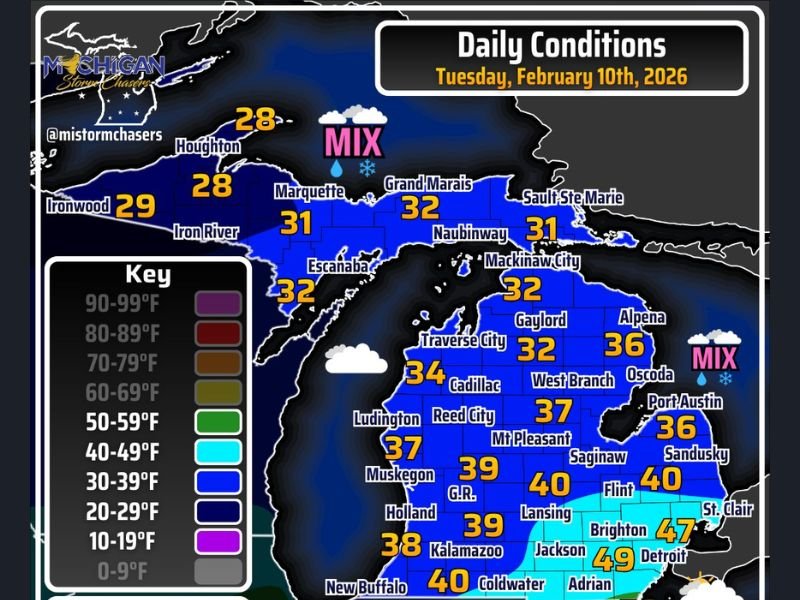
The temperature map shows a sharp north-to-south gradient, highlighting how limited the warmer air will be across the state.
Where Temperatures Will Be Warmest
The warmest air is expected in southeastern Michigan, where temperatures rise into the 40s and may briefly touch 50 degrees in parts of southern Monroe County.
Notable warmer readings shown include:
- Detroit: 49°F
- Adrian: 49°F
- Jackson: 47°F
- Flint: 40°F
- Lansing: 40°F
The data notes that this warmer zone extends roughly 20 miles north or south, making the near-50-degree readings highly confined.
Most of Michigan Remains Cold
Outside of the southeast corner, temperatures across Michigan remain firmly in the 30s, with colder readings farther north.
Examples from the map include:
- Grand Rapids: 39°F
- Kalamazoo: 38°F
- Muskegon: 37°F
- Cadillac: 34°F
- Gaylord: 32°F
- Marquette: 31°F
- Houghton: 28°F
These values show that much of the state continues to experience winter-level cold despite the brief southern warm-up.
Mixed Precipitation Early, Then Clearing
The data indicates that snow and freezing rain are expected to start the day across northeastern Michigan and the Thumb, with some areas experiencing a wintry mix. Conditions are expected to improve and clear later in the evening.
Southern portions of the state, particularly in the southeast, are more likely to see sunshine, which aligns with where temperatures will be warmest.
Gusty Winds Add to the Chill
In addition to cold temperatures, northwest winds are increasing across Michigan. Sustained winds are expected between 10 and 20 mph, with gusts exceeding 30 mph in many locations. While most areas are not expected to reach 40 mph gusts, the wind will make temperatures feel colder, especially outside the warmer southeast pocket.
What This Means for the Day Ahead
Tuesday’s weather highlights a brief and uneven warm-up, limited mainly to southeastern Michigan. For most residents, winter conditions remain in place, with cold temperatures, gusty winds, and early-day wintry precipitation before gradual improvement later.
For continued data-driven weather updates, regional temperature trends, and daily condition reports, follow coverage on NapervilleLocal.com, where changing weather patterns across the country are tracked clearly and responsibly.

I’ve lived in Naperville long enough to see how quickly our community changes — from new developments downtown to sudden shifts in our Midwest weather. Reporting on Naperville news and daily forecasts gives me the chance to keep neighbors informed about what really matters. My goal is simple: deliver clear, timely updates so you always know what’s happening in our city and what to expect from the skies above.