
Michigan Sees Milder Friday With 40s Across Southern Cities, 30s in Snow-Covered North, Calm Winds and Patchy Fog Into Saturday
MICHIGAN — A quiet and noticeably milder Friday is unfolding across the state, with temperatures rebounding into the 40s in areas where snowpack has diminished, while communities still holding onto deeper snow remain stuck in the 30s. After weeks of persistent winter patterns, February 13 is shaping up to be one of the calmer days on the calendar.
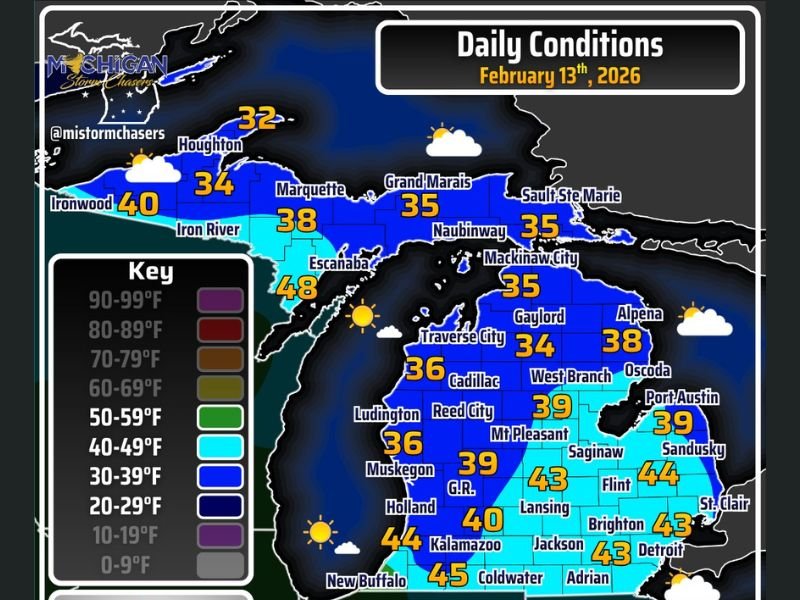
Snowpack Dictates Today’s Temperature Spread
Where snow cover is minimal, readings are climbing back into the 40s. Locations across southern Lower Michigan are leading the warmup:
- Kalamazoo: 44°F
- Coldwater: 45°F
- Lansing: 43°F
- Flint: 44°F
- Detroit and Adrian: 43°F
- Grand Rapids (G.R.): around 39–40°F
Meanwhile, northern Lower Michigan and the Upper Peninsula remain cooler due to ongoing snowpack:
- Traverse City: 36°F
- Gaylord: 34°F
- Alpena: 38°F
- Houghton: 32°F
- Marquette: 38°F
- Grand Marais: 35°F
- Sault Ste. Marie: 35°F
In western Upper Michigan, Ironwood reaches 40°F, while Escanaba stands out at 48°F — one of the warmest readings in the U.P. today.
Areas with thicker snowpack are holding temperatures in the mid- to upper-30s, as the snow limits how much the ground can warm.
Dry Skies and Plenty of Sunshine
Precipitation chances across Michigan today are essentially zero. Skies will range from partly cloudy to mostly sunny after patchy morning fog clears. Not every location will see fog, but where it forms, it should gradually lift through the morning hours. With calm winds statewide, the mild afternoon air will feel comfortable for mid-February standards.
Fog Risk Returns Tonight Into Saturday Morning
Winds remain light through the evening, which increases the potential for additional fog development overnight. Calm conditions combined with lingering surface moisture could allow fog to redevelop late Friday night into early Saturday morning. Motorists should watch for localized visibility reductions, especially near lakes, rivers, and low-lying areas.
Quiet Pattern Continues for Now
Michigan remains in a short-term inactive weather pattern, meaning no significant storm systems are expected immediately. This stretch offers a break from the more active winter conditions experienced earlier in the season.
For now, Friday delivers a mix of 40s in southern Michigan, 30s across the snow-covered north, dry skies, and calm winds — a welcome and relatively peaceful February day across the state. NapervilleLocal.com will continue tracking broader Midwest and Great Lakes trends that could signal future pattern shifts affecting the region.

I’ve lived in Naperville long enough to see how quickly our community changes — from new developments downtown to sudden shifts in our Midwest weather. Reporting on Naperville news and daily forecasts gives me the chance to keep neighbors informed about what really matters. My goal is simple: deliver clear, timely updates so you always know what’s happening in our city and what to expect from the skies above.