
Tornado Threat Expands from North Texas to Louisiana After Dark on Valentine’s Day, With Damaging Winds and Embedded Twisters Possible
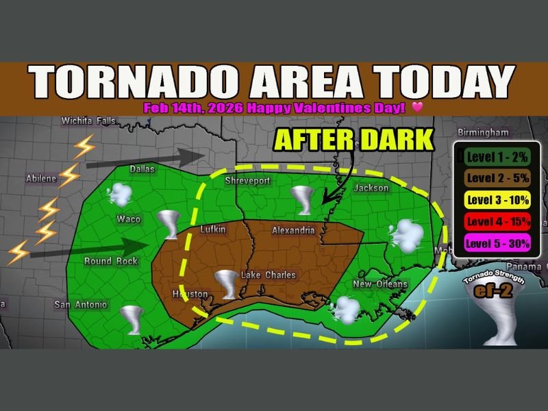
TEXAS AND LOUISIANA — A developing severe weather setup is expected to intensify late Friday, February 14, 2026, as a line of storms pushes east from North Texas into Louisiana, bringing the threat of damaging winds and possible tornadoes — especially after sunset.
Forecasters indicate that a messy morning line of storms across northern Texas will continue moving east throughout the day. While activity may temporarily weaken, it is expected to reorganize and strengthen late this afternoon and into the evening as it taps into deeper Gulf moisture and a strengthening low-level jet stream.
Storm Line Strengthening Across North Texas
The current storm activity stretches across portions of North Texas, including areas near Dallas, Waco, Round Rock, and Houston. As the line advances eastward, it will encounter more favorable atmospheric conditions for severe development.
The main concerns include:
- Damaging straight-line winds
- Embedded QLCS (quasi-linear convective system) tornadoes
- Heavy rainfall and lightning
The risk area includes much of eastern Texas, including Lufkin and areas near the Gulf Coast.
Highest Risk Shifts Toward Louisiana After Dark
As storms move into western and central Louisiana during the evening hours, the environment is expected to become more supportive of tornado development.
Cities including:
- Shreveport
- Lake Charles
- Alexandria
- New Orleans
- Jackson, Mississippi
are all within the broader risk zone shown in forecast guidance.
The greatest tornado potential appears to be in a Level 2 (5%) probability zone after dark, particularly across central and southern Louisiana. While this is not a widespread high-end outbreak scenario, embedded tornadoes within the line of storms are possible and may occur with limited warning due to nighttime timing.
Why Evening Storms Are More Dangerous
Storms that intensify after sunset can pose added danger because:
- Many people are indoors and less likely to receive warnings.
- Visibility is reduced, making tornadoes harder to see.
- A strengthening low-level jet can increase wind shear, enhancing rotation within storm lines.
Forecasters are urging residents in the risk areas to ensure weather radios and mobile alerts are enabled before going to bed.
Valentine’s Day Weather Disruption Possible
With the severe weather threat peaking late afternoon through the overnight hours, Valentine’s Day evening plans across parts of Texas and Louisiana could be disrupted by strong storms.
While not everyone in the highlighted area will see severe weather, conditions are favorable for scattered damaging wind events and a couple of tornadoes embedded within the line.
Residents across eastern Texas and much of Louisiana should monitor updates through the evening and have a shelter plan ready in case warnings are issued. For continued national weather updates and detailed breakdowns of developing storm systems, stay connected with NapervilleLocal.com.

I’ve lived in Naperville long enough to see how quickly our community changes — from new developments downtown to sudden shifts in our Midwest weather. Reporting on Naperville news and daily forecasts gives me the chance to keep neighbors informed about what really matters. My goal is simple: deliver clear, timely updates so you always know what’s happening in our city and what to expect from the skies above.