
Strong Low-Pressure System to Track Directly Across Georgia Friday, Bringing Widespread Rain, Thunderstorms, and Noticeable Pressure Impacts
GEORGIA — A powerful storm system is set to move directly across the state on Friday, February 14, 2026, bringing widespread rain, embedded thunderstorms, and a noticeable drop in atmospheric pressure as the center of a developing low passes overhead.
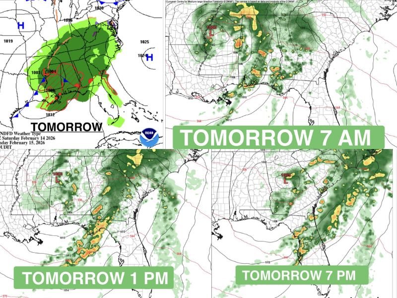
Forecast maps show a strengthening low-pressure system organizing to the west before tracking straight through Georgia during the day. While severe weather does not appear widespread at this time, areas shaded in red on forecast guidance indicate the potential for thunderstorms, particularly across central and southern portions of the state.
Low-Pressure Center Moves Across the State
The system’s core — marked by falling surface pressures around 1003–1005 mb — is forecast to move from Alabama into Georgia during the morning and afternoon hours.
By 7 a.m., rain will already be spreading across western Georgia, with pockets of heavier showers developing.
By 1 p.m., the low is expected to be moving into central Georgia, with more organized bands of rain and embedded storms lifting north and east.
By 7 p.m., the system will continue tracking across eastern Georgia, gradually pushing rain toward the Carolinas while lingering showers remain across parts of the state.
Because the low will pass very close to or directly over portions of Georgia, residents may experience:
- Periods of steady rainfall
- Brief heavier downpours
- Isolated thunder
- Gusty winds near stronger showers
North Georgia Likely to See Steady Rain
Forecast guidance suggests that North Georgia may primarily experience a soaking rainfall rather than widespread severe storms. However, thunder cannot be ruled out, particularly if instability increases during the afternoon. Central and southern Georgia appear more likely to see the stronger embedded thunderstorms as moisture deepens and lift increases around the low’s center.
Pressure Changes May Be Noticeable
One unique aspect of this setup is the direct passage of the low-pressure center across the region. When atmospheric pressure drops quickly, some residents report:
- Headaches
- Sinus pressure
- Joint discomfort
While not a hazard in the traditional sense, rapid pressure changes can be noticeable — especially for those sensitive to weather swings.
What to Expect Overall
At this time, the system looks more like a widespread rain event with embedded thunder, rather than a high-end severe outbreak. Still, locally heavier downpours could lead to brief ponding on roads, especially during peak travel hours. The heaviest activity is expected during the daytime and early evening hours before gradually shifting east overnight.
Residents across Georgia should plan for a wet Friday, monitor local forecasts for updates, and allow extra time for travel in periods of heavier rain. For continued national storm system updates and regional weather breakdowns, stay connected with NapervilleLocal.com.

I’ve lived in Naperville long enough to see how quickly our community changes — from new developments downtown to sudden shifts in our Midwest weather. Reporting on Naperville news and daily forecasts gives me the chance to keep neighbors informed about what really matters. My goal is simple: deliver clear, timely updates so you always know what’s happening in our city and what to expect from the skies above.