
Powerful Valentine’s Day Storm Brings Tornado Threat to Texas and Louisiana While Cold Rain Spreads Across the Deep South
UNITED STATES — A dynamic and potentially dangerous storm system is sweeping east across the Deep South and Gulf Coast this Valentine’s Day, bringing a sharp divide in weather conditions from Texas to the Carolinas.
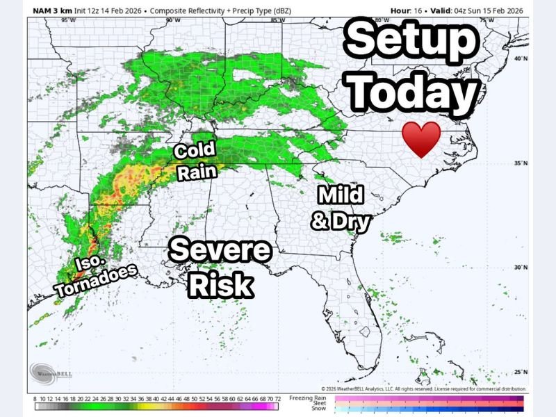
While parts of the Southeast will remain mild and dry for now, a more volatile setup is unfolding farther west, where severe storms — including isolated tornadoes — are possible.
Severe Risk Focused on East Texas and Louisiana
The strongest impacts today are expected across East Texas and Louisiana, where sufficient instability and strong wind energy are combining to support severe thunderstorms.
A line of storms developing across eastern Texas is expected to intensify as it moves east. Forecasters highlight:
- Damaging straight-line winds
- Large hail
- Isolated tornado potential
- Strongest storms developing along the advancing line
Areas near Houston, Lufkin, Shreveport, and Lake Charles sit within the corridor most vulnerable to severe weather as the system tracks toward the Gulf Coast.
Cold, Steady Rain North of the Severe Zone
Farther north — across portions of Arkansas, Mississippi, northern Alabama, and Tennessee — the primary impact will be a cold, steady rain rather than severe storms.
This region sits north of the warm sector where instability is limited, reducing the tornado threat but still bringing widespread wet conditions. Travel disruptions and ponding on roadways may become the main concern in these areas as rain persists.
Mild and Dry for Now Across the Southeast
Ahead of the system, much of Georgia, the Carolinas, and parts of Florida remain in a relatively quiet pattern for Valentine’s Day, with mild temperatures and dry conditions. However, that calm will not last.
Severe Threat Shifts East on Sunday
By Sunday, the storm’s energy pushes farther east. The severe weather threat is expected to shift into:
- South Alabama
- South Georgia
- Portions of Florida
A Level 2 (Slight Risk) has been issued for parts of this region as the system reorganizes and encounters favorable atmospheric conditions. This is the time of year when late-winter systems can take on spring-like characteristics — producing strong winds, embedded tornadoes, and fast-moving storm lines.
What This Means for the Midwest
While the immediate severe threat remains concentrated along the Gulf Coast and Deep South, systems like this often signal a broader seasonal transition. As these powerful southern systems track east, they frequently influence downstream weather patterns, eventually affecting states farther north in the days that follow.
Residents across the affected southern states should remain weather-aware today and through Sunday, especially in tornado-prone areas. For continued national storm tracking and regional weather updates, stay with NapervilleLocal.com.

I’ve lived in Naperville long enough to see how quickly our community changes — from new developments downtown to sudden shifts in our Midwest weather. Reporting on Naperville news and daily forecasts gives me the chance to keep neighbors informed about what really matters. My goal is simple: deliver clear, timely updates so you always know what’s happening in our city and what to expect from the skies above.