
More Than 3,000 Lightning Strikes Slam North Texas by 8 A.M., Intense Storm Cluster Targets Gainesville, Sherman and Bowie on Valentine’s Day
UNITED STATES — A powerful early-morning storm complex erupted across North Texas on Valentine’s Day, producing more than 3,000 lightning strikes by 8 a.m. and prompting safety concerns across multiple communities west and north of Dallas–Fort Worth.
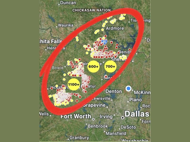
The most concentrated lightning activity developed in a corridor stretching from Bowie and Jacksboro northeast through Gainesville, Sherman, and Ardmore, with storms clustering along and west of the I-35 corridor.
Lightning Hotspots West and North of Dallas–Fort Worth
Mapping data shows several intense lightning cores, with strike totals surpassing:
- 1,100+ strikes near the Bowie and Jacksboro area
- 600+ strikes around Gainesville
- 700+ strikes near Sherman
Additional lightning activity extended north toward Ardmore and across portions of southern Oklahoma, including areas within the Chickasaw Nation. Meanwhile, the immediate Dallas metro — including Plano, McKinney, Irving, and Denton — appeared just east of the most intense lightning clusters during the early-morning hours.
Storms Producing Frequent Cloud-to-Ground Lightning
Forecasters emphasized that lightning can strike miles away from the heaviest rainfall. Even areas not directly under the strongest storm cores may still experience dangerous electrical activity.
The return of lightning is notable, as some areas had not recorded thunderstorm activity since November. The sudden spike in storm energy marks a sharp change from recent quieter conditions. With repeated lightning bursts occurring in tight clusters, residents across North Texas were urged to:
- Postpone outdoor plans
- Move activities indoors
- Avoid open fields and elevated areas
- Stay off water until storms fully clear
Valentine’s Day Plans May Be Disrupted
The timing of the storms — developing early in the morning and continuing through the day — could impact holiday travel, outdoor events, and daytime activities. Storm clusters appear aligned in a southwest-to-northeast orientation, suggesting the potential for additional lightning development as the system progresses eastward. Even after heavy rain shifts, lightning risk may linger on the backside of the storms.
What This Means for the Midwest
While the most intense lightning activity remains centered over North Texas and southern Oklahoma, storm systems like this often track eastward, eventually influencing downstream weather patterns.
As this system evolves, forecasters will monitor how moisture and energy shift across the central United States in the coming days. For continued national storm tracking and regional weather coverage, stay with NapervilleLocal.com.

I’ve lived in Naperville long enough to see how quickly our community changes — from new developments downtown to sudden shifts in our Midwest weather. Reporting on Naperville news and daily forecasts gives me the chance to keep neighbors informed about what really matters. My goal is simple: deliver clear, timely updates so you always know what’s happening in our city and what to expect from the skies above.