
Valentine’s Day 2026 Brings Foggy Start and 40s to Low-50s Across Michigan, With I-94 Corridor Seeing the Warmest Afternoon Highs
UNITED STATES — Valentine’s Day is delivering a quiet but slightly tricky weather setup across Michigan, with morning fog, cool early temperatures, and a gradual afternoon warm-up into the 40s and low 50s for parts of the state.
While this isn’t a true spring preview, it’s a noticeable break from harsher winter conditions — especially for mid-February.
Morning Fog and Evaporative Cooling Limit Early Warmth
The biggest weather factor early Saturday is lingering fog, especially across parts of northern and central Michigan. Light winds are allowing fog to hang around longer in some communities, which may hold temperatures down during the first half of the day.
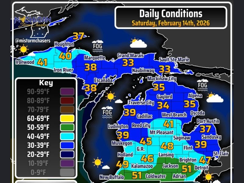
Cities across northern Michigan remain cooler:
- Grand Marais – 33°
- Sault Ste. Marie – 33°
- Mackinaw City – 35°
- Gaylord – 34°
- Alpena – 35°
- Marquette – 38°
- Escanaba – 38°
- Houghton – 37°
Patchy fog may also create slick spots, especially where moisture briefly froze on untreated surfaces. Drivers are urged to use headlights and allow extra stopping distance during the morning hours.
Southern Michigan Pushes Into the Upper 40s and Low 50s
Farther south — particularly along and south of the I-94 corridor — afternoon temperatures climb higher under mostly to partly sunny skies once fog dissipates.
Projected highs include:
- Detroit – 47°
- Brighton – 47°
- Lansing – 48°
- Grand Rapids – 45°
- Kalamazoo – 49°
- Jackson – 51°
- Adrian – 51°
- Coldwater – 51°
These readings put much of southern Michigan solidly in the 40s, with a few lower-50s readings possible in spots where sunshine holds longest.
No Precipitation, Light Winds, and a Quiet Pattern
Unlike many recent winter systems, no snow, sleet, or rain is expected statewide today. Winds are light, contributing to both the morning fog and a calmer overall feel. The quiet conditions are expected to continue through much of the day before any changes arrive later in the weekend.
What This Means for Naperville and the Midwest
While this setup is centered over Michigan, it reflects a broader milder pattern developing across parts of the Midwest. As air masses shift eastward, similar temperature moderation trends can influence surrounding states in the coming days.
Residents across Illinois and the Chicago metro should continue monitoring local forecasts as late-winter systems remain active nationally. For continued Midwest weather updates and regional forecast analysis, stay connected with NapervilleLocal.com.

I’ve lived in Naperville long enough to see how quickly our community changes — from new developments downtown to sudden shifts in our Midwest weather. Reporting on Naperville news and daily forecasts gives me the chance to keep neighbors informed about what really matters. My goal is simple: deliver clear, timely updates so you always know what’s happening in our city and what to expect from the skies above.