
Sunday Line of Storms Targets Florida and the Southeast With Marginal to Slight Severe Risk as Daytona 500 Weather Remains Uncertain
UNITED STATES — A fast-moving line of showers and thunderstorms is expected to sweep across parts of the Deep South and Florida on Sunday evening, with new model guidance showing timing that could impact portions of the Florida Peninsula, including areas near Daytona Beach.
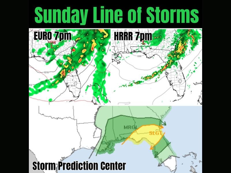
Latest projections from the EURO and HRRR models, both initialized for around 7 p.m. Sunday, show a defined band of storms pushing eastward across the Gulf Coast states and into Florida.
Models Show Fast-Moving Line Crossing Florida
The EURO 7 p.m. projection indicates widespread rain and embedded thunderstorms stretching from the eastern Gulf Coast into north and central Florida. Heavier pockets of storms appear concentrated along a southwest-to-northeast axis.
Meanwhile, the HRRR 7 p.m. model shows a narrower but more organized squall line moving across northern and central Florida, with storms advancing quickly offshore into the Atlantic later Sunday night.
Both models agree on:
- A fast-moving system
- A defined line of convection
- Storm activity progressing east through the evening hours
Timing remains a key question, especially for outdoor events scheduled Sunday evening.
SPC Highlights Marginal and Slight Risk Areas
The Storm Prediction Center (SPC) has outlined parts of the Southeast under organized severe weather risk zones.
The latest outlook shows:
- A Marginal Risk (MRGL) covering portions of the central Gulf Coast and Southeast
- A more focused Slight Risk (SLGT) extending across parts of north and central Florida and into southern Georgia
These categories suggest the possibility of:
- Isolated strong wind gusts
- Brief tornado potential
- Localized heavier rainfall
While not signaling a widespread outbreak, the setup supports enough instability and wind shear to justify monitoring conditions closely.
Florida Peninsula in the Primary Focus
The heaviest storm corridor appears aligned from the eastern Gulf Coast through:
- Tallahassee region
- Jacksonville vicinity
- Central Florida
- Toward the Atlantic Coast
Areas farther north into Alabama and Georgia may see steadier rain, but the more organized severe potential is focused closer to Florida. Storms are expected to move quickly, limiting prolonged impacts in any single location.
What Happens Next
The key factors to watch over the next 24 hours include:
- Exact storm timing across Florida
- Whether instability increases ahead of the line
- Any strengthening of low-level wind shear
For now, the system appears progressive and not stalled — which reduces flooding concerns but keeps the focus on wind and isolated tornado potential. NapervilleLocal.com will continue monitoring national weather trends that could eventually influence Midwest conditions as this active pattern evolves.

I’ve lived in Naperville long enough to see how quickly our community changes — from new developments downtown to sudden shifts in our Midwest weather. Reporting on Naperville news and daily forecasts gives me the chance to keep neighbors informed about what really matters. My goal is simple: deliver clear, timely updates so you always know what’s happening in our city and what to expect from the skies above.