
132 MPH Wind Gust Reported West of Lafayette, Louisiana as Powerful Overnight Storm Line Rips Across Acadiana
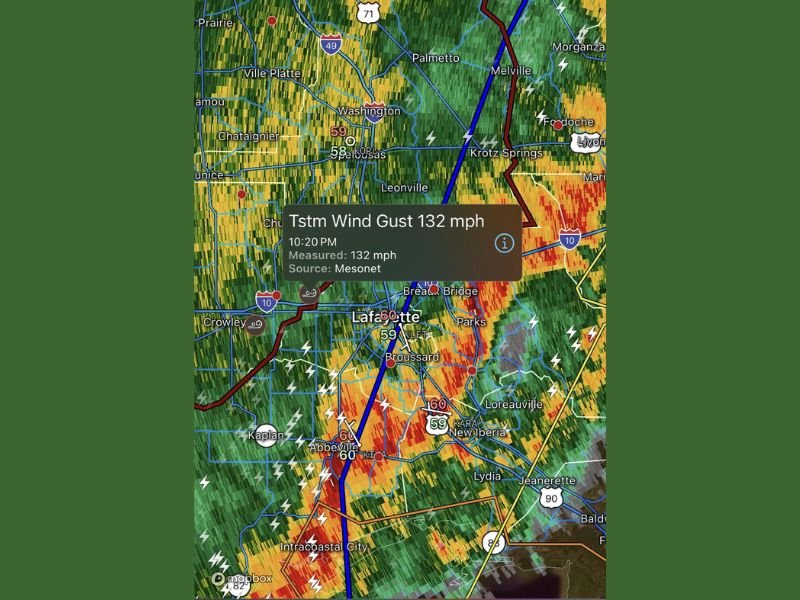
Lafayette, Louisiana — A powerful overnight line of storms tore through Acadiana late Saturday night, producing a staggering 132 mph wind gust west of Lafayette as the system surged across south-central Louisiana. The extreme gust was recorded at 10:20 p.m., according to Mesonet data, highlighting the intensity of the fast-moving squall line that forecasters had been tracking for hours.
Radar imagery shows a well-defined line of severe thunderstorms stretching from near Ville Platte and Washington southward through Lafayette, Broussard, New Iberia, and toward Intracoastal City. The strongest winds were reported just west of Lafayette, with intense radar returns indicating heavy rain and embedded storm cores capable of producing destructive gusts.
Storm Line Brings Destructive Winds Across Lafayette Area
The storm complex advanced eastward across major corridors including Interstate 10 and communities such as Crowley, Breaux Bridge, and Abbeville. Bright red and orange radar signatures pointed to areas of the most intense wind and rainfall. Lightning activity was widespread across the region, particularly south of Lafayette near Kaplan and Intracoastal City.
The reported 132 mph gust stands out as exceptionally strong and is comparable to wind speeds seen in high-end tornadoes or major hurricanes. While further verification may determine the exact classification of the wind event, such a reading signals significant potential for structural damage, downed power lines, and fallen trees.
Residents across Broussard, Parks, and New Iberia likely experienced rapid shifts in wind intensity as the storm line passed. Gusty conditions also extended north toward Krotz Springs and Melville, where radar showed heavy precipitation and lightning.
Widespread Impact Possible Across South-Central Louisiana
With wind speeds exceeding hurricane force in localized areas, damage assessments are expected across portions of Lafayette Parish and surrounding communities. Storm lines of this magnitude often produce scattered power outages and debris along roadways, particularly in areas with mature tree cover.
The squall line maintained strong forward momentum as it tracked east of Lafayette toward Loreauville, Jeanerette, and eventually deeper into southern Louisiana. Given the intensity of radar returns, localized flash flooding cannot be ruled out where heavy rainfall occurred in short bursts.
Emergency management officials typically urge residents to remain indoors during such events, avoid travel during peak wind periods, and report downed power lines immediately. With lightning strikes visible across much of the radar scan, additional hazards extended beyond damaging wind.
Severe weather outbreaks like this underscore how quickly conditions can escalate along the Gulf Coast, especially during overnight hours when visibility and response time are limited. For continued updates on significant weather events impacting communities across the country, visit NapervilleLocal.com for detailed coverage and regional storm analysis.

I’ve lived in Naperville long enough to see how quickly our community changes — from new developments downtown to sudden shifts in our Midwest weather. Reporting on Naperville news and daily forecasts gives me the chance to keep neighbors informed about what really matters. My goal is simple: deliver clear, timely updates so you always know what’s happening in our city and what to expect from the skies above.