
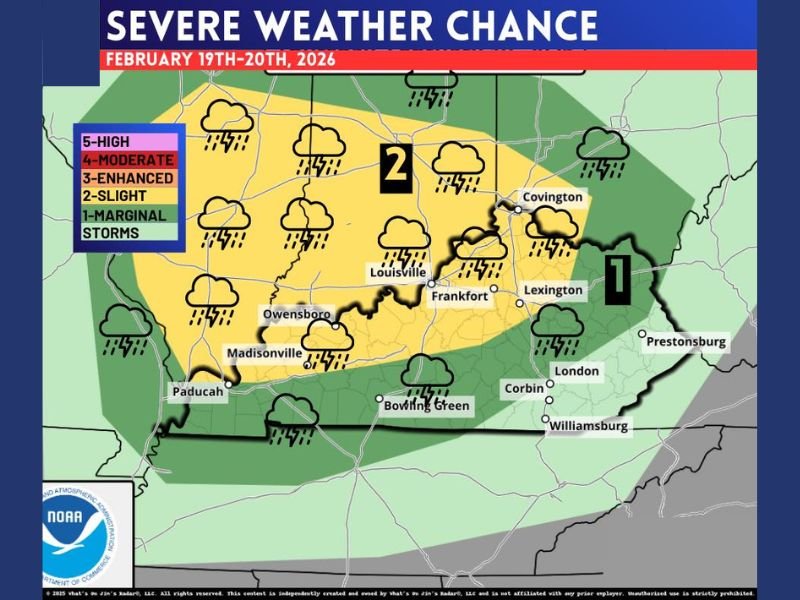
Kentucky Under Level 2 Severe Weather Risk Thursday as Louisville, Lexington and Western Counties Face Damaging Storm Potential
KENTUCKY — A developing severe weather setup is drawing attention across the state for Thursday, February 19–20, 2026, with much of central and western Kentucky placed under a Level 2 “Slight Risk.” Forecasters indicate scattered severe storms are possible, particularly in cities such as Louisville, Frankfort, Owensboro, Paducah, and Lexington.
Eastern Kentucky, including Prestonsburg and surrounding Appalachian communities, remains under a Level 1 “Marginal Risk,” meaning isolated severe storms could still develop, though coverage would likely be more limited.
What Level 2 Means for Central and Western Kentucky
A Level 2 Slight Risk does not mean widespread destruction, but it does signal a stronger potential for organized storms capable of producing damage.
Within the highlighted corridor stretching from western Kentucky through Louisville and into Lexington, storms could generate damaging wind gusts, hail, and possibly a brief tornado. Not every location will experience severe weather, but a few storms could intensify quickly.
How Level 1 Risk Differs in Eastern Kentucky
Communities in eastern Kentucky remain in a lower-tier threat zone. A Level 1 Marginal Risk suggests severe storms are possible but expected to be isolated and less widespread.
Even so, a single stronger thunderstorm could still produce gusty winds or hail, especially if atmospheric conditions become more favorable than currently projected.
Timing and Storm Setup
The primary concern window appears to be Thursday afternoon into Thursday night. A dynamic system moving across the region will bring instability and wind energy supportive of thunderstorms.
Heavy rain and frequent lightning are likely across much of the state. Forecasters will continue refining details on storm timing, strength, and any potential tornado threat as Thursday approaches.
Staying Prepared
While this is not currently categorized as a high-end outbreak scenario, residents across Louisville, Lexington, Bowling Green, Owensboro, and surrounding counties should monitor updates closely. Have multiple ways to receive warnings, especially if storms develop during evening or overnight hours.
For continued updates on severe weather patterns and regional storm developments, stay connected with NapervilleLocal.com and check back for the latest forecast details as conditions evolve.

I’ve lived in Naperville long enough to see how quickly our community changes — from new developments downtown to sudden shifts in our Midwest weather. Reporting on Naperville news and daily forecasts gives me the chance to keep neighbors informed about what really matters. My goal is simple: deliver clear, timely updates so you always know what’s happening in our city and what to expect from the skies above.