
Michigan Braces for Sloppy Thursday: Fog, Thunderstorms South of I-94, Snow in the U.P. and Freezing Rain Risk Tonight
MICHIGAN — A messy and impactful weather day is unfolding across the state on Thursday, February 19, 2026, with fog and low clouds early, thunderstorms developing south of I-94, snow in the Upper Peninsula, and a growing threat of freezing rain later tonight north of Mount Pleasant. Forecasters describe it simply: another sloppy day incoming.
Foggy Start Before Storms Expand
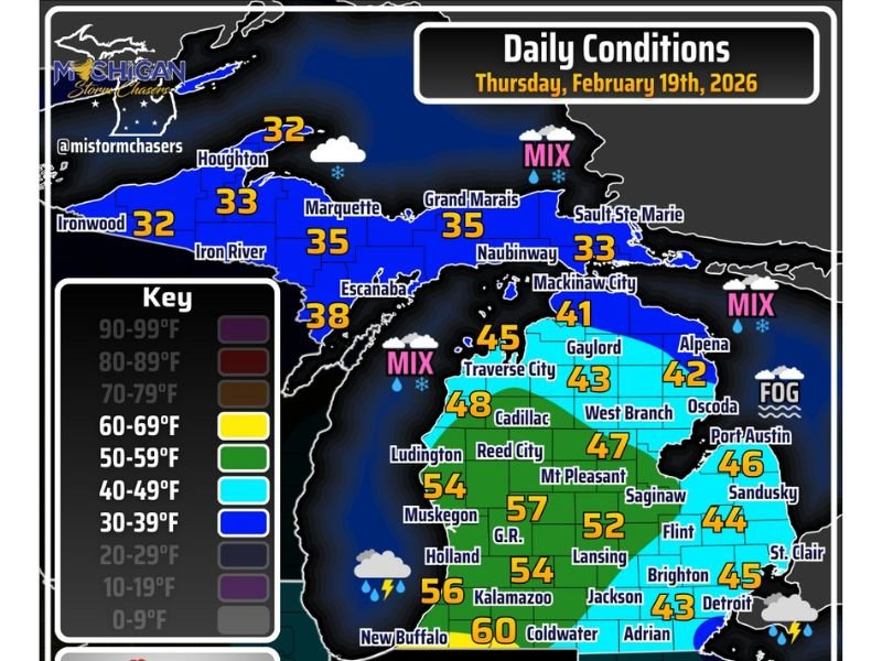
The morning began with mostly cloudy skies and areas of fog across portions of Lower Michigan. As the day progresses, precipitation becomes more widespread. Across the Upper Peninsula, snow will be hit-or-miss through the day, with temperatures generally in the low to mid-30s:
- Houghton: 32°F
- Ironwood: 32°F
- Marquette: 35°F
- Escanaba: 38°F
- Sault Ste. Marie: 33°F
Further south in Lower Michigan, showers increase in coverage through the afternoon and evening, with thunderstorms returning to parts of the state.
Stronger Storms Possible South of I-94
Storm activity is expected to intensify during the afternoon and evening, particularly south of Interstate 94. A couple of storms could become strong or even severe in southern sections of the state.
Temperatures in southern Lower Michigan support instability:
- Kalamazoo: 56°F
- Grand Rapids: 57°F
- Lansing: 52°F
- Jackson: 43°F
- Coldwater: 60°F
- Detroit: 45°F
The warmer air in the southwest portion of the state provides fuel for thunderstorms before colder air filters in later tonight.
Wintry Mix and Freezing Rain Risk Tonight
As temperatures cool this evening, precipitation type becomes more complicated. North of Mount Pleasant, rain is expected to transition to freezing rain and sleet overnight. Some areas could even experience isolated thundersleet as colder air wraps into the system.
Northern Lower Michigan cities such as:
- Gaylord: 43°F
- Alpena: 42°F
- Oscoda: 46°F
- West Branch: 47°F
- Cadillac: 48°F
could see a mix develop as temperatures fall. The Upper Peninsula remains colder, with snow continuing in spots and stronger winds developing.
Strongest Winds Target the Upper Peninsula
Wind gusts will be strongest across the Upper Peninsula, compounding travel issues in areas experiencing snow or mixed precipitation. Blowing snow and reduced visibility may become concerns in exposed areas, particularly later in the day.
Rain Totals and Ice Jam Concerns
Many locations could pick up an additional half inch of rainfall, providing much-needed moisture but also raising hydrological concerns.
Hydrologic outlooks have already been issued, and residents living along larger rivers and streams should monitor for potential ice jam issues, especially where snowmelt and rainfall combine.
The Bottom Line: A High-Impact, Multi-Threat Day
From fog and thunderstorms in southern Michigan to snow and strong winds in the Upper Peninsula — and freezing rain threats overnight — nearly every part of the state will experience some form of impactful weather today.
Residents are encouraged to remain weather aware through tonight as conditions change rapidly from region to region. For continued updates on Midwest weather developments and regional impacts, stay connected with NapervilleLocal.com.

I’ve lived in Naperville long enough to see how quickly our community changes — from new developments downtown to sudden shifts in our Midwest weather. Reporting on Naperville news and daily forecasts gives me the chance to keep neighbors informed about what really matters. My goal is simple: deliver clear, timely updates so you always know what’s happening in our city and what to expect from the skies above.