
Ohio Tornado Warning Issued as Severe Storm Near Springboro Moves East at 35 MPH Toward Dayton-Area Communities
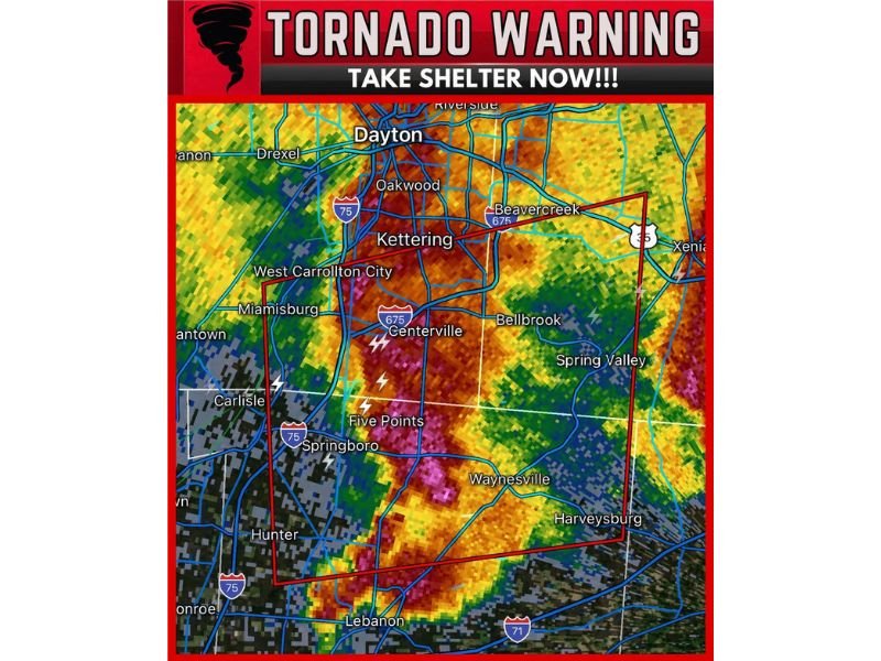
OHIO — A tornado warning was issued after a severe thunderstorm capable of producing a tornado was located over Springboro and moving east at 35 mph, with the warning polygon covering a large portion of the Dayton-area corridor shown on radar.
The warning area includes communities stretching from the southern side of the metro northward toward Dayton, with storm motion carrying the most intense part of the line across neighborhoods and major routes in a short time window. The radar presentation shows a highly organized storm structure, with the strongest core positioned in and around the warning box as it advances east.
Communities in the Warning Area and Storm Track
Based on the locations displayed in the warning map, the storm’s path and immediate risk zone includes multiple populated areas and travel corridors. Places shown within or near the warned polygon include Kettering, Centerville, Bellbrook, Beavercreek, Miamisburg, West Carrollton City, and areas labeled Five Points, Waynesville, Spring Valley, and Harveysburg.
The graphic also places the warned storm close to the broader Dayton metro area, with nearby labels including Oakwood, Riverside, and Xenia. Farther south, the map shows the system in the vicinity of Lebanon, with additional nearby place markers such as Carlisle, Hunter, and regional highways that can quickly become dangerous if visibility drops or debris is blown onto roadways.
Because the storm is moving at 35 mph, any location along the warned corridor may see conditions change rapidly, especially if the storm produces a brief tornado or damaging straight-line winds.
What “Tornado-Capable” Means in This Situation
A tornado warning indicates that meteorologists have detected a storm with features that can support tornado development, or a tornado may be occurring. The radar image associated with this warning shows a powerful line segment with intense reflectivity, which can be associated with damaging wind and rotating segments embedded within the storm.
Even if a tornado does not touch down, storms of this type can still produce dangerous impacts, including sudden wind gusts, lightning, and fast-moving heavy rain that can reduce visibility to near zero. The “take shelter now” message is meant to be acted on immediately, not watched from windows or porches.
What Residents Should Do Right Now
If you are inside the warned area, treat this as an urgent situation:
- Move to a basement if available, or an interior room on the lowest floor
- Stay away from windows, exterior walls, and garage doors
- If in an apartment or mobile home, seek a sturdy shelter immediately
- Keep shoes, a flashlight, and a charged phone nearby in case of debris or power loss
- Do not drive through the warned area unless absolutely necessary, as winds can topple trees and power lines quickly
This warning is focused on the Springboro-to-Dayton area corridor as the storm advances east. Continue monitoring official alerts and be prepared to take shelter again if additional warnings are issued.

I’ve lived in Naperville long enough to see how quickly our community changes — from new developments downtown to sudden shifts in our Midwest weather. Reporting on Naperville news and daily forecasts gives me the chance to keep neighbors informed about what really matters. My goal is simple: deliver clear, timely updates so you always know what’s happening in our city and what to expect from the skies above.