
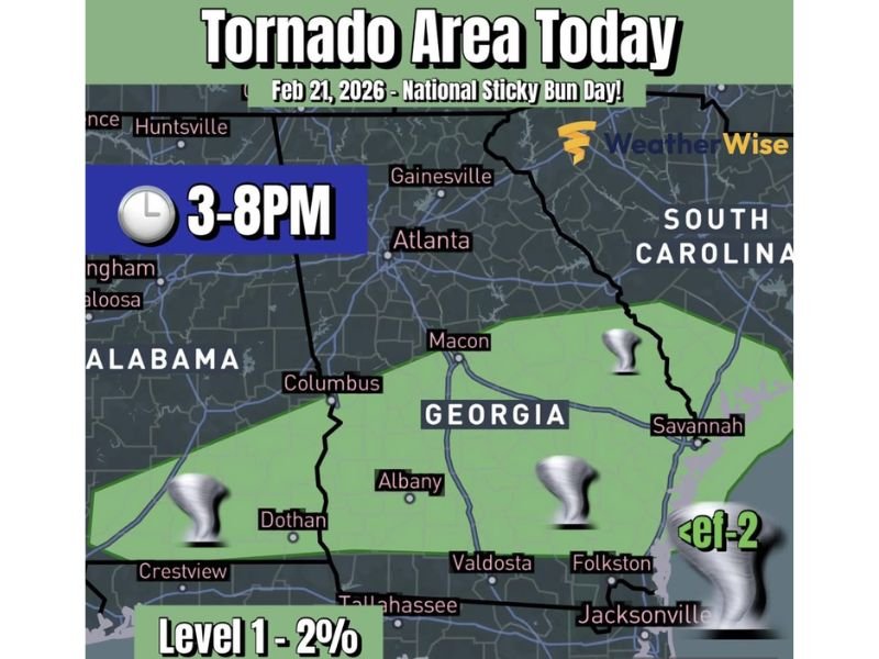
Alabama and Georgia Face a Late-Day Storm Line With a Low-End Tornado Risk, Gusty Winds and Small Hail Possible Between 3–8 PM
ALABAMA — A line of thunderstorms is expected to develop by late afternoon across southern Alabama and southern Georgia, bringing a low-end tornado risk along with the possibility of gusty winds and small hail during a defined evening window. Forecasters emphasize that widespread significant severe weather is not expected, but there is enough atmospheric “juice and spin” that one or two storms could briefly become stronger than the rest.
The risk area shown covers a broad strip from the Florida Panhandle side of Alabama eastward through southern Georgia, with the most active period highlighted as 3 p.m. to 8 p.m. The outlook labels the threat as Level 1 with about a 2% tornado probability, which is considered low, but not zero.
Storm Timing: Why 3–8 PM Is the Window to Watch
The forecast highlights late afternoon into early evening as the time storms are most likely to organize into a line. That timing matters because daytime heating can help storms strengthen, and as they form into a line, brief rotations can develop in pockets—sometimes producing quick tornado spin-ups.
Even in low-end setups, the greatest impact risk often comes from:
- Sudden wind gusts that can knock down limbs
- Quick, heavy downpours reducing visibility
- Small hail in stronger cores
- A brief tornado that forms and dissipates quickly
Because the storms are expected to be moving through during evening hours, residents should plan for rapidly changing conditions as the line approaches.
Locations Shown in the Risk Area
The map and labels highlight multiple cities within or near the low-end tornado zone. In Alabama, the risk area includes locations near Dothan and stretches toward Crestview in the Florida Panhandle region. In Georgia, the highlighted area includes Columbus, Macon, Albany, Valdosta, and communities closer to the coast such as Savannah.
Farther southeast, the risk shading extends toward the Florida-Georgia border region near Jacksonville and communities like Folkston, where brief storm rotations can sometimes develop along boundary lines.
The outlook notes that most storms will not do anything severe, but the idea is that one or two storms anywhere in the zone could briefly intensify.
What “Level 1” Risk Means for Residents
A Level 1 outlook is not a guarantee of damaging weather. It is a signal that conditions support isolated stronger storms, even if the overall event is expected to remain manageable. In practical terms, that means residents should not panic, but they should stay alert for warnings, especially during the 3–8 PM window.
Simple Safety Steps for the Evening
Residents in southern Alabama and Georgia can reduce risk by taking a few steps:
- Keep a way to receive warnings (phone alerts, local weather radio)
- Secure outdoor items that could blow around in gusty winds
- Avoid driving through heavy rain when visibility drops
- If a warning is issued, move to an interior room away from windows
This remains a lower-end setup, but forecasters are tracking it closely because even weak tornadoes can cause damage if they pass through populated areas. For more weather updates written in a clear, local-news style, visit NapervilleLocal.com.

I’ve lived in Naperville long enough to see how quickly our community changes — from new developments downtown to sudden shifts in our Midwest weather. Reporting on Naperville news and daily forecasts gives me the chance to keep neighbors informed about what really matters. My goal is simple: deliver clear, timely updates so you always know what’s happening in our city and what to expect from the skies above.