
Blizzard Warning Issued for Jersey Coast, New York City and Long Island as Winter Storm Hernando Targets Mid-Atlantic Into New England Through Monday Afternoon
UNITED STATES — A major coastal winter storm is escalating into a high-impact event for the Mid-Atlantic and New England, with Blizzard Warnings now in place for the Jersey Coast, New York City and Long Island through Monday afternoon. The latest snow forecast tied to Winter Storm Hernando shows the potential for widespread disruptive totals, with the heaviest band aimed at the I-95 corridor and the New England shoreline where snowfall could pile up fast and winds may drive whiteout conditions.
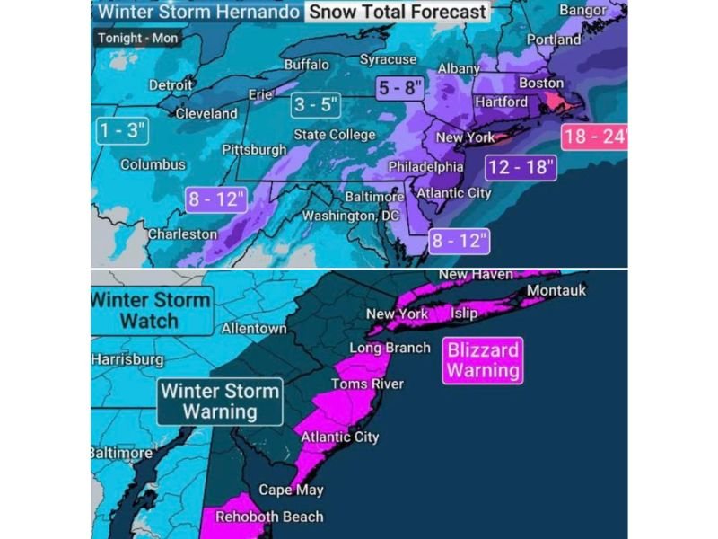
Forecast graphics indicate this storm could produce up to 2 feet of snow in the hardest-hit coastal zones, while inland areas still see significant accumulation capable of making roads impassable for stretches of time.
Heaviest Snow Target: NYC to Coastal New England
The snow-total forecast highlights a sharp gradient, with the biggest totals clustered near the coast. The most intense accumulation zone is shown near southern New England, where 18–24 inches is possible in the core band near the Boston area. Farther southwest, the corridor from New York toward coastal Connecticut and Long Island is marked for 12–18 inches, putting the metro region in line for a plow-challenging snow that can snarl travel and create dangerous conditions during peak snowfall rates.
In the Mid-Atlantic, totals are still expected to be substantial. The forecast shows 8–12 inches in parts of the Washington-Baltimore region and across areas tied to Philadelphia and the coastal plain, with similar 8–12 inch potential near Atlantic City depending on how the coastal low tracks and where the heaviest band sets up.
Blizzard Warning Zone: Jersey Shore and Long Island Coastal Communities
The warning map shows the blizzard-highlighted zone running along the New Jersey coastline and extending into parts of the New York metro shoreline and Long Island. Specific locations displayed within or near the blizzard-highlighted area include Long Branch, Toms River, Atlantic City, and Cape May, with the warning shading also reaching down toward Rehoboth Beach. Farther northeast, the warning zone extends across the New York City area and along Long Island, including communities labeled near Islip and Montauk, where strong winds over open water can drive blowing snow and rapid visibility drops.
What This Means for Travel and Daily Life
With a blizzard warning, the biggest concern is not only the snow depth but the combination of heavy snow and strong wind. That mix can create:
- Near-zero visibility at times from blowing and drifting snow
- Rapidly deteriorating roads, even after plows pass
- Major delays and cancellations at regional airports
- Potential power problems in coastal communities if wind becomes severe
What to Do Before Conditions Peak
Residents in the warning corridor should plan for periods when travel becomes unsafe and consider finishing errands early. If you must travel, keep routes flexible and monitor local alerts, because the worst banding can shift and change which metro areas see the most intense snowfall.
For continued storm updates written in a clear, local-news style, visit NapervilleLocal.com.

I’ve lived in Naperville long enough to see how quickly our community changes — from new developments downtown to sudden shifts in our Midwest weather. Reporting on Naperville news and daily forecasts gives me the chance to keep neighbors informed about what really matters. My goal is simple: deliver clear, timely updates so you always know what’s happening in our city and what to expect from the skies above.