
New York, New Jersey, Massachusetts and Maine Brace for Major Nor’easter With 12+ Inches and 50+ MPH Winds
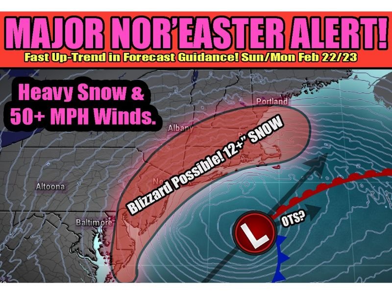
UNITED STATES — Forecast guidance is trending sharply toward a classic Nor’easter scenario in the Northeast, with a rapidly strengthening coastal low expected to develop Sunday morning and linger through Monday. Recent model “uptrends” suggest a swath of heavy snow and strong winds could impact parts of the Mid-Atlantic and New England, and forecasters are warning that travel may become dangerous or even ill-advised if blizzard conditions materialize.
Some projections show extreme snowfall potential, including localized totals exceeding two feet in the most intense banding. More conservative solutions still point to a significant storm, commonly clustering around 12–14 inches in the higher-impact corridor. The main message in the latest outlook is that the system appears increasingly likely to track close enough to the coastline to produce heavy snow, not just light accumulations.
Where the Heaviest Snow Looks Most Likely
The highest-impact zone is focused near the coast, with the potential for a “blizzard possible” snow band setting up from portions of New Jersey into southern New England, including parts of New York and Massachusetts, and extending toward areas of Maine. Cities and regions referenced in the latest briefing imagery include Baltimore (Maryland) on the southern fringe, Altoona (Pennsylvania) inland, and Albany (New York) farther north and west of the coastline.
While inland areas can still see substantial snow, the strongest signal for intense snowfall rates remains closer to the I-95 corridor and coastal New England, where the storm’s strongest moisture and lift would be most concentrated.
Winds Over 50 MPH Could Create Whiteouts and Drifting
Along with heavy snow, the storm is expected to intensify quickly as the low pressure system “bombs out” offshore. That kind of rapid strengthening can ramp up winds to 50+ mph, raising the risk of whiteout conditions, blowing and drifting snow, and rapidly deteriorating road conditions.
Even if snowfall totals end up lower in some communities, strong wind can still produce near-blizzard impacts by reducing visibility and making snow removal difficult.
Why a 50-Mile Track Shift Still Matters
Forecasters caution that the difference between a major coastal blizzard and a more moderate event may come down to the storm’s exact track. A shift of roughly 50 miles can relocate the heaviest snow axis and change totals dramatically from one metro area to the next. There is also still an outside chance the storm could jog farther out to sea, which would reduce impacts inland and along parts of the coast.
However, the latest discussion emphasizes that, with the storm close and trends pointing toward a coastline-influencing track, confidence is increasing that this system will not simply slide harmlessly out to sea.
What Residents Should Do Now
With Sunday into Monday highlighted as the highest-risk period, residents in the Northeast should prepare for rapidly changing conditions, including potential road closures, flight delays, and power outage risks where wet snow and strong wind combine. If you must travel, have a backup plan and be ready to adjust quickly as updated warnings and snowfall bands become clearer.

I’ve lived in Naperville long enough to see how quickly our community changes — from new developments downtown to sudden shifts in our Midwest weather. Reporting on Naperville news and daily forecasts gives me the chance to keep neighbors informed about what really matters. My goal is simple: deliver clear, timely updates so you always know what’s happening in our city and what to expect from the skies above.