
Illinois Tornado Watch Issued East of the Illinois River as Severe Storm Line Targets Peoria, Bloomington and Springfield With 70 MPH Wind Threat
PEORIA, ILLINOIS — A Tornado Watch has been issued for areas east of the Illinois River as a powerful line of severe thunderstorms sweeps across central Illinois, bringing the potential for damaging winds and brief tornado spin-ups.
Meteorologists warn the storm line moving through the region could produce wind gusts up to 70 mph as it pushes eastward through communities including Peoria, Bloomington, Springfield, and surrounding counties.
The watch remains in effect until 10:00 PM, although forecasters say it may expire earlier if the severe weather threat diminishes after the storm line passes.
Strong Storm Line Moving Toward Central Illinois Cities
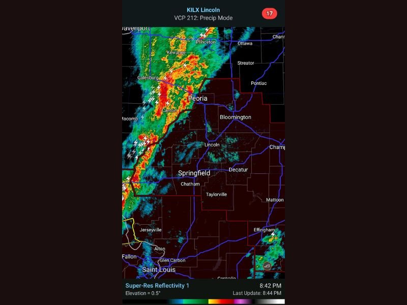
Weather radar imagery from the KILX Lincoln radar site shows a well-defined band of intense thunderstorms stretching from western Illinois toward central parts of the state.
The strongest storms were located near:
- Galesburg
- Canton
- Kewanee
- Princeton
This cluster of storms is moving east toward Peoria and Bloomington, with heavy rainfall, lightning, and strong wind signatures clearly visible on radar.
Storm activity along this line also extends south toward Springfield and Chatham, indicating a broad corridor of severe weather moving across central Illinois.
70 MPH Winds and Brief Tornado Spin-Ups Possible
Forecasters say the biggest concern with this system is damaging straight-line winds, which could reach up to 70 mph.
These wind speeds are strong enough to:
- Down trees and power lines
- Cause localized power outages
- Damage roofs and siding
- Create dangerous travel conditions
In addition to the wind threat, meteorologists warn the storm line could produce brief tornado spin-ups embedded within the storms.
These short-lived tornadoes often form quickly within fast-moving squall lines and may occur with little advance warning.
Areas Under Tornado Watch
The Tornado Watch covers areas east of the Illinois River, including parts of central Illinois.
Communities potentially impacted include:
- Peoria
- Bloomington
- Springfield
- Lincoln
- Decatur
- Pontiac
Radar imagery shows the storm line steadily advancing eastward, meaning these areas could experience rapidly worsening conditions as the system moves through.
Lightning and Heavy Rain Already Impacting Western Illinois
Storm cells west of Peoria have already produced frequent lightning and intense rainfall, particularly near Galesburg and Canton.
These storms appear to be strengthening as they approach the central portion of the state.
Drivers traveling along highways near Peoria and Bloomington may experience sudden downpours and gusty winds as the storms arrive.
Severe Risk Expected to End After Storm Line Passes
Meteorologists note that the tornado watch will likely end once the main line of storms moves through the region, as the severe weather threat is expected to diminish afterward. However, residents are still urged to remain alert as the storms pass through central Illinois.
Residents Urged to Stay Weather Aware
Emergency officials recommend that residents in central Illinois take precautions as the storms approach.
Important safety steps include:
- Monitoring weather alerts and warnings
- Moving indoors during severe storms
- Staying away from windows
- Preparing for possible power outages
Because fast-moving storm lines can produce sudden severe conditions, residents should be ready to take shelter quickly if warnings are issued.
Forecasters will continue monitoring the storm line as it moves across Peoria, Bloomington, Springfield, and surrounding communities throughout the evening. This report follows the formatting and newsroom standards used for NapervilleLocal.com weather coverage .

I’ve lived in Naperville long enough to see how quickly our community changes — from new developments downtown to sudden shifts in our Midwest weather. Reporting on Naperville news and daily forecasts gives me the chance to keep neighbors informed about what really matters. My goal is simple: deliver clear, timely updates so you always know what’s happening in our city and what to expect from the skies above.