
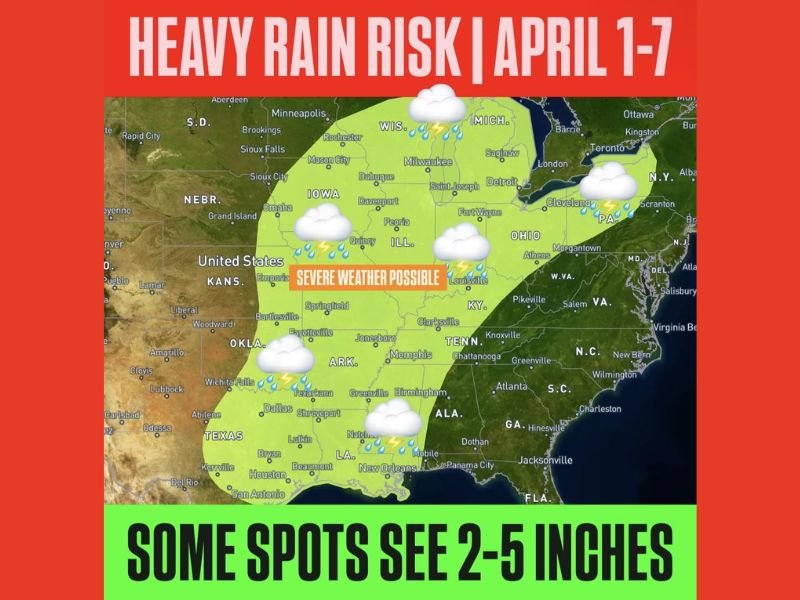
Texas, Arkansas, Louisiana, Mississippi, Alabama, Tennessee, Kentucky, Illinois, Indiana, Ohio, Michigan and Pennsylvania Face Heavy Rain Risk April 1 Through April 7 With 2 to 5 Inches Possible
UNITED STATES — A widespread and potentially impactful heavy rain pattern is expected to develop during the first week of April, with a large portion of the central and eastern United States facing the risk of prolonged rainfall. This setup could bring multiple rounds of storms across several days, increasing the likelihood of higher rainfall totals and localized flooding concerns across the region.
The outlook, covering April 1 through April 7, highlights a broad corridor where repeated storm systems may track over the same areas, allowing rain to accumulate steadily over time rather than falling in a single event.
Large Multi-State Region Included in Rain Threat
The risk area spans a wide portion of the country, beginning in Texas and extending northeast through Arkansas, Louisiana, Mississippi, Alabama, Tennessee, and Kentucky. From there, the zone continues into Illinois, Indiana, Ohio, Michigan, and Pennsylvania, covering a significant portion of the Midwest and Great Lakes.
This type of large-scale coverage suggests a well-organized weather pattern capable of influencing multiple regions at once, rather than a localized storm system. Communities across this corridor may experience multiple periods of rain rather than a single storm, which can increase total rainfall over time.
Rainfall Totals Could Reach 2 to 5 Inches
Forecast guidance indicates that rainfall totals could reach between 2 to 5 inches in some locations, particularly in areas where storms repeatedly move across the same region. These totals are significant, especially when spread over several days, and can lead to saturated ground conditions.
In some cases, isolated areas could exceed these amounts if heavier storms develop or stall, leading to more intense rainfall over shorter periods.
Storm System May Bring Repeated Rounds of Rain
The overall setup points to a pattern where storms may develop in waves, moving across the same general areas over multiple days. This is often referred to as a “training” pattern, where storms follow a similar path repeatedly.
When this happens, even moderate rainfall events can add up quickly, increasing the risk of water accumulation and making it harder for the ground to absorb additional rain.
Severe Weather Also Possible Within the Region
Along with heavy rainfall, parts of the region may also see periods of strong to severe thunderstorms. These storms could bring additional hazards such as gusty winds, lightning, and bursts of very heavy rain.
While the primary concern remains rainfall totals, the presence of thunderstorms could lead to localized areas experiencing more intense impacts in shorter timeframes.
Flooding Risk Could Develop in Vulnerable Areas
With several inches of rain possible, the risk of localized flooding will increase, especially in areas prone to water accumulation. Low-lying regions, urban areas with poor drainage, and locations near rivers or streams may be more vulnerable.
Flooding may not occur everywhere, but areas that receive repeated heavy rainfall could see rising water levels, particularly if drainage systems become overwhelmed.
What Happens Next
Forecast models will continue to refine the placement, timing, and intensity of rainfall as the event approaches. Small shifts in the storm track could determine which areas receive the heaviest rain.
Residents across Texas, the Lower Mississippi Valley, the Midwest, and into the Great Lakes should remain alert and monitor updates as this extended rain event develops over the coming days. Stay with NapervilleLocal.com for continued updates on this developing heavy rain pattern and potential flooding risks across the United States.

I’ve lived in Naperville long enough to see how quickly our community changes — from new developments downtown to sudden shifts in our Midwest weather. Reporting on Naperville news and daily forecasts gives me the chance to keep neighbors informed about what really matters. My goal is simple: deliver clear, timely updates so you always know what’s happening in our city and what to expect from the skies above.