
Illinois, Indiana, Ohio and Michigan Enter Thursday Tornado Risk Zone as Forecast Signals Possible Significant Twister and Hail Up to 3 Inches
INDIANAPOLIS, INDIANA — A dangerous severe weather setup is taking shape across parts of the Midwest for Thursday, with forecasters warning that conditions may support tornadoes, including the potential for at least one significant tornado. The same storm environment could also produce very large hail, with sizes reaching up to 3 inches in diameter in the strongest storms.
The highest concern stretches from northern and central Illinois through much of Indiana and into northwest and central Ohio, with parts of southern Michigan also included on the northern edge of the threat zone. This corridor is now being closely watched because the atmospheric ingredients appear unusually favorable for rotating storms.
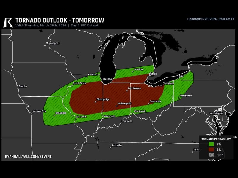
Tornado Risk Zone Covers a Large Part of the Midwest
The outlook shows a broad tornado risk area extending from eastern Missouri and Illinois across Indiana and into Ohio, with cities such as Chicago, Champaign, Indianapolis, Fort Wayne, Columbus, and Cleveland all within or near the highlighted zone. Southern Michigan, including areas near Lansing and Detroit, is also included on the northern side of the outlook.
Within that broader area, the more concerning zone is centered across Illinois, Indiana, and Ohio, where the map highlights a stronger tornado probability. That does not mean tornadoes will occur everywhere in the risk area, but it does mean storms that form in this corridor may have a better chance of becoming severe and rotating.
Forecast Setup Favors Rotating Severe Storms
One of the biggest reasons this setup is drawing attention is the strength of the wind profile across the region. Forecasters indicate that winds at different levels of the atmosphere are lined up in a way that can help thunderstorms organize, rotate, and potentially produce tornadoes.
When this type of wind structure combines with warm, unstable air, storms can become much more intense than ordinary spring thunderstorms. That is especially important in a corridor from northern Illinois into northwest Ohio, where the ingredients appear most supportive of stronger supercell development.
Significant Tornado Cannot Be Ruled Out
The outlook specifically notes that the atmosphere has enough spin to produce tornadoes, and possibly a significant one. That wording stands out because it suggests concern not just for brief or isolated spin-ups, but for the chance that one storm could become more dangerous if it fully taps into the environment.
Even though tornado forecasts can still change as storm timing and exact placement become clearer, this kind of signal is enough to make Thursday a day that residents across the region should take seriously. A setup like this can evolve quickly once storms begin forming.
Very Large Hail Also a Major Concern
Along with the tornado threat, very large hail is also on the table across the Midwest risk zone. The forecast mentions hail up to 3 inches, which is large enough to cause significant damage to vehicles, roofs, siding, and windows.
Hail of that size is typically associated with intense rotating storms that have extremely strong updrafts. If supercells develop before storms merge into a larger line, the hail threat could become one of the most damaging parts of this event in some communities.
Key Cities From Chicago to Columbus Need Close Monitoring
Major population centers including Chicago, Indianapolis, Fort Wayne, Columbus, Cleveland, and nearby surrounding areas all sit close to or within the highlighted tornado outlook. That means this is not a remote rural-only setup. If storms strengthen in the expected corridor, impacts could reach heavily traveled roads, neighborhoods, and evening activities across multiple states.
Because the threat zone covers such a wide area, the exact timing and storm mode will matter greatly. Some places may deal with isolated supercells first, while others could see storms organize later into a broader severe complex.
What Happens Next
Forecast updates through the day will refine where the strongest storms are most likely to develop and how the threat shifts from afternoon into evening. Residents across Illinois, Indiana, Ohio, and southern Michigan should make sure they have multiple ways to receive warnings and a safe place identified before storms begin to fire.
With tornado potential, very large hail, and a strongly favorable wind setup all present in the forecast, Thursday is shaping up to be one of the more serious severe weather days the Midwest has faced this week. Stay with NapervilleLocal.com for continued updates as this Thursday severe weather threat develops across the Midwest.

I’ve lived in Naperville long enough to see how quickly our community changes — from new developments downtown to sudden shifts in our Midwest weather. Reporting on Naperville news and daily forecasts gives me the chance to keep neighbors informed about what really matters. My goal is simple: deliver clear, timely updates so you always know what’s happening in our city and what to expect from the skies above.