
North Dakota South Dakota Minnesota Snow Band Targets Northern Plains With 3 to 7 Inches Along Highway Corridors
BISMARCK, NORTH DAKOTA — A narrow but impactful band of snowfall is setting up across parts of North Dakota, South Dakota, and Minnesota, with several northern areas expected to receive measurable accumulation. The system is expected to move quickly but could still create travel issues where heavier snow develops.
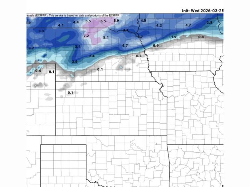
Snow Band Focused Across Northern Tier
Forecast data indicates the heaviest snowfall will stretch across northern North Dakota into northern Minnesota, where totals are expected to range between 4 to 7 inches. Some localized areas may see higher-end totals, particularly near the North Dakota–Minnesota border.
Northern South Dakota is also in the path of this band, with expected snowfall generally between 2 to 5 inches. This creates a corridor of moderate accumulation across the upper portion of the region.
Sharp Cutoff Leaves Southern Areas Mostly Dry
A defining feature of this system is the sharp cutoff in snowfall amounts. Areas just south of the main band, including central South Dakota and nearby regions, are likely to see minimal accumulation — often near or below a half inch.
This means conditions could vary significantly within short distances, with snow-covered roads in northern counties while areas farther south remain mostly dry.
Travel Concerns Along Key Routes
The alignment of this snow band suggests potential impacts along key highways running through North Dakota and into Minnesota. Travelers could encounter rapidly changing conditions, especially during periods of heavier snowfall.
Possible impacts include:
- Snow-covered and slick roadways
- Reduced visibility during bursts of snow
- Quick accumulation over a short time
Even though the system is relatively narrow, its intensity could still lead to localized travel disruptions.
Fast-Moving System Increases Short-Term Impact
This snowfall event is expected to pass through quickly, concentrating most of its impact into a shorter window. Because of this, snow could accumulate faster than it can be cleared in some areas.
Northern regions will see the most consistent snowfall, while southern areas may only experience light flurries or remain unaffected.
What Residents Should Expect Next
Residents across northern North Dakota, South Dakota, and Minnesota should stay prepared for changing conditions, particularly if traveling. While not a widespread storm, this focused snow band could still create noticeable disruptions where it sets up.
Officials continue monitoring the system, as even slight shifts in its track could change which communities receive the heaviest snowfall.
Stay connected with NapervilleLocal.com for the latest weather updates, regional forecasts, and real-time alerts as this system moves across the Northern Plains.

I’ve lived in Naperville long enough to see how quickly our community changes — from new developments downtown to sudden shifts in our Midwest weather. Reporting on Naperville news and daily forecasts gives me the chance to keep neighbors informed about what really matters. My goal is simple: deliver clear, timely updates so you always know what’s happening in our city and what to expect from the skies above.