
Birmingham, Montgomery, Huntsville, Tuscaloosa, Mobile See Warm Dry Start Then Midweek Rain and Easter Weekend Storm Risk Across Alabama
ALABAMA — A quiet and warm start to the week is underway across the state, but a noticeable shift toward wetter and more unsettled weather is expected as the days progress, with rain chances increasing by midweek and potential storm impacts heading into Easter weekend.
Warm and Quiet Conditions to Start the Week
Early-week conditions across Alabama remain calm and comfortable, with temperatures climbing into the upper 60s today under a light southeast breeze.
Looking ahead to Monday:
- Highs are expected to approach 80°F statewide
- Conditions remain mostly dry
- Overnight lows will stay mild, generally in the 50s
This brief stretch offers a classic early spring warmup before the next system approaches.
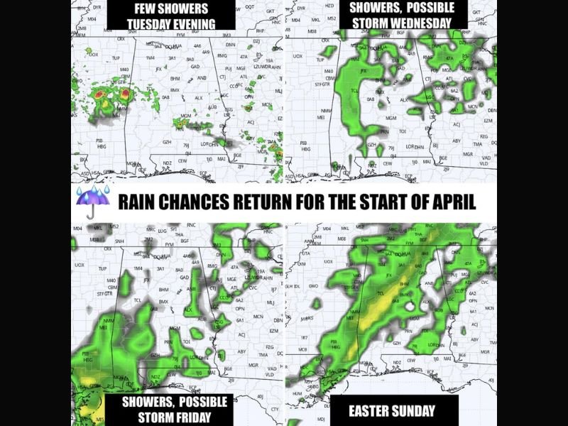
Rain Chances Begin Tuesday Evening
The first signs of change arrive Tuesday evening, when isolated showers may begin to develop across parts of the state. While coverage will initially be limited, this marks the beginning of a more active pattern.
Better Rain Coverage Wednesday and Thursday
By midweek, moisture increases significantly, bringing more widespread rain chances across Alabama.
Forecast trends indicate:
- Wednesday and Thursday: Higher coverage of showers
- Periods of steady rainfall possible
- Limited storm intensity early, but increasing potential later
This phase will bring needed moisture but also signal a transition toward a more unsettled pattern.
Storm Chances Increase by Friday
By Friday, the setup becomes more favorable for thunderstorms.
Residents across Birmingham, Montgomery, Huntsville, Tuscaloosa, and Mobile could see:
- More organized rain bands
- Embedded thunderstorms
- Heavier rainfall at times
While severe weather is not guaranteed, the pattern suggests at least some storm potential heading into the weekend.
Easter Weekend Outlook Brings Storm Concerns
Attention then turns to the Easter weekend, when a cold front is expected to move into Alabama.
Current projections show:
- Saturday: Stronger storms more likely west of Alabama
- Sunday (Easter): Storm system moves into the state, though slightly weakened
- Continued monitoring needed for potential impacts
Even with some weakening, forecasters emphasize that Sunday will need close attention, as storms could still affect parts of the region.
Cooler Air Follows Next Week
After the active period, a cooler air mass is expected to move in, with temperatures trending downward:
- Overnight lows dropping into the upper 30s and 40s
- No major frost or freeze concerns at this time
What This Means for Alabama Residents
For communities across Birmingham, Montgomery, Huntsville, Tuscaloosa, and Mobile, the week ahead features a clear progression:
- Warm and dry conditions early in the week
- Increasing rain chances starting Tuesday evening
- More widespread showers midweek
- Potential storms heading into Easter weekend
This evolving pattern highlights the transition into a more active spring weather phase across the Southeast. Stay with NapervilleLocal.com for continued updates as forecasters refine the timing and severity of rain and storm chances across Alabama and the broader region.

I’ve lived in Naperville long enough to see how quickly our community changes — from new developments downtown to sudden shifts in our Midwest weather. Reporting on Naperville news and daily forecasts gives me the chance to keep neighbors informed about what really matters. My goal is simple: deliver clear, timely updates so you always know what’s happening in our city and what to expect from the skies above.