
Detroit, Grand Rapids, Lansing, Kalamazoo Warm Into 60s and 70 Near Indiana Border Before Late Night Storms Sweep Across Michigan
MICHIGAN — A calm and pleasant spring setup will take hold across much of the state Monday, but a late-night shift toward thunderstorms and increasing rainfall is expected as the day transitions into early Tuesday.
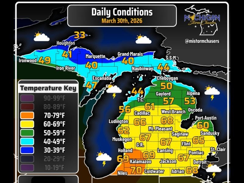
Warm and Comfortable Conditions Take Over Monday
Temperatures across the Lower Peninsula will climb into the 60s and even low 70s, especially toward southern areas near the Indiana border. Cities like Detroit, Lansing, Grand Rapids, Kalamazoo, and Jackson are expected to see highs ranging from the mid-60s to near 70°F, creating one of the warmest days in recent weeks.
Meanwhile, cooler air will hold across northern areas:
Locations near Grayling and northern Lower Michigan will remain in the 40s and 50s, while the Upper Peninsula, including cities like Marquette and Houghton, will stay cooler in the 30s to low 40s. Skies will remain partly cloudy, with a light southwest breeze around 6 to 12 mph, and occasional gusts exceeding 20 mph.
Storm Threat Builds Late Tonight
Despite the quiet daytime weather, conditions will begin to change later tonight as a system approaches from the west. Thunderstorms are expected to move into the Lower Peninsula late Monday night, continuing into early Tuesday morning.
The best chance for storms will develop after 11 PM EDT, with activity spreading across much of the state overnight.
While not all storms are expected to be severe, the setup suggests:
Increasing rainfall overnight
Periods of thunder and lightning
Locally heavier downpours in some areas
Rainfall Totals Could Climb Quickly
As the system moves through, rainfall totals will begin to add up, with some locations potentially seeing over one inch of rain by early Wednesday. This will mark a notable shift from the recent dry stretch and could bring temporary relief to dry conditions in some regions.
Northern Michigan Remains Cooler and More Stable
While storms move through the Lower Peninsula overnight, northern areas and parts of the Upper Peninsula may experience more scattered activity with less intensity. Temperatures there will remain cooler overall, and instability will be more limited compared to southern Michigan.
What This Means Moving Forward
Monday will offer a brief window of mild, enjoyable spring weather, but residents should be prepared for a noticeable overnight transition into a wetter and more unsettled pattern.
The combination of warmth during the day and incoming moisture overnight signals the beginning of a more active stretch of weather heading into midweek. Residents are encouraged to stay aware of overnight conditions, especially those traveling late or early Tuesday. Stay with NapervilleLocal.com for continuing updates as storms develop across Michigan and the broader Midwest.

I’ve lived in Naperville long enough to see how quickly our community changes — from new developments downtown to sudden shifts in our Midwest weather. Reporting on Naperville news and daily forecasts gives me the chance to keep neighbors informed about what really matters. My goal is simple: deliver clear, timely updates so you always know what’s happening in our city and what to expect from the skies above.