
Colorado, Kansas and Nebraska Face Rapid Weather Swings With Windy Monday, Cold Front Tuesday and Midweek Storm Bringing Rain, Snow and Storms
DENVER, COLORADO — A highly active and fast-changing weather pattern is set to unfold across Colorado and surrounding Plains states this week, beginning with warm and windy conditions before transitioning into a colder, storm-filled midweek setup.
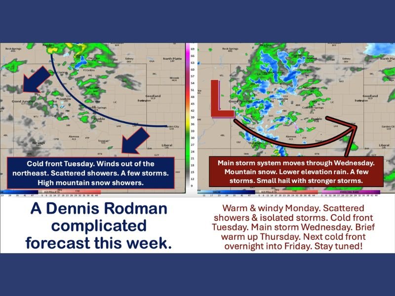
The forecast highlights multiple shifts in temperature, wind direction, and precipitation types, making this one of the more complex weather weeks for the region.
Warm and Windy Conditions Kick Off Monday
Monday begins with warm temperatures and increasing winds across Colorado, particularly along the Front Range and eastern plains. West winds are expected to range between 5 to 15 mph, with gusts climbing into the 25 to 35 mph range.
These conditions, combined with low humidity and compressional heating, are expected to elevate fire danger levels, especially in drier areas. In addition to the wind, a few high-based showers and isolated storms may develop, bringing lightning and brief gusty conditions.
Cold Front Brings Sudden Shift Overnight Into Tuesday
A significant change arrives overnight as a cold front moves north to south across the region. This will shift winds to the northeast, maintaining gusts in the 25 to 35 mph range, particularly across eastern Colorado, western Kansas, and parts of Nebraska.
By Tuesday, temperatures will drop noticeably:
- 50s to low 60s across much of Colorado
- Near 70 degrees in southern Colorado ahead of the front
- Low 70s across western slope regions
Winds will vary depending on location, with easterly flow east of the Continental Divide and westerly winds to the west, creating a split weather pattern.
Rain is expected in lower elevations, while snow develops in higher mountain areas, along with scattered showers and isolated storms east of the Divide.
Wednesday Storm System Brings Main Impact
The most significant weather arrives Wednesday as a larger storm system moves through the region.
This system is expected to bring:
- Mountain snow across higher elevations
- Rain across valleys and lower elevations
- A few thunderstorms, some capable of small hail
The combination of moisture and instability could lead to widespread precipitation, making Wednesday the most impactful day of the week.
Brief Warm-Up Before Another Temperature Drop
Conditions will briefly improve on Thursday, with most areas warming back into the 70s, although lingering snow may continue in northern mountain regions. However, this break will be short-lived.
Another Cold Front Expected Late Week
Another cold front is expected to move through Thursday night into Friday, bringing another round of cooler temperatures and the potential for additional precipitation.
Depending on how the system tracks, the region could see:
- More mountain snow
- Rain or mixed precipitation at lower elevations
- Or simply a return to windy and cooler conditions
Forecast confidence decreases later in the week, as models remain uncertain about the exact path of the system.
Uncertain End to the Week With Changing Conditions
By Friday into Saturday, weather conditions will depend heavily on storm track. The system could either shift north, limiting impacts, or trend colder and wetter across a broader area. Beyond that, the pattern remains uncertain, described as a “chaotic neutral” setup, meaning conditions could continue to shift rapidly.
Residents across Colorado, Kansas, and Nebraska should stay alert and prepared for changing weather conditions throughout the week as this dynamic pattern unfolds. Stay with NapervilleLocal.com for continued updates on this evolving weather system.

I’ve lived in Naperville long enough to see how quickly our community changes — from new developments downtown to sudden shifts in our Midwest weather. Reporting on Naperville news and daily forecasts gives me the chance to keep neighbors informed about what really matters. My goal is simple: deliver clear, timely updates so you always know what’s happening in our city and what to expect from the skies above.