
Illinois, Indiana, Ohio and New York Face Fast Moving Severe Storms With 75 to 90 Knot Jet Fueling Damaging Winds and Large Hail Risk Today
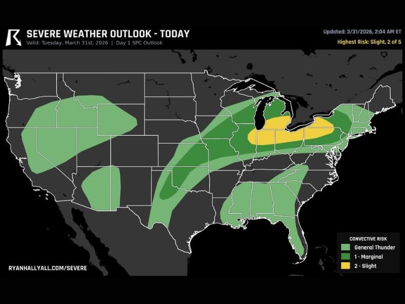
CHICAGO, ILLINOIS — A fast-moving severe weather setup is unfolding today across the Midwest and Northeast, with a Level 2 risk stretching from northeast Illinois through Indiana, Ohio, and into western New York.
The primary concern is a surge of powerful storms driven by a 75 to 90 knot mid-level jet, creating conditions favorable for damaging winds and large hail from the afternoon into tonight.
Severe Storm Corridor Extends Across Midwest Into Northeast
Forecast data shows a defined severe weather corridor beginning in northeast Illinois, including the Chicago area, and extending eastward through Indiana, Ohio, and into western New York.
This region is under a Level 2 (Slight Risk) classification, indicating a higher chance of scattered severe storms capable of producing impactful weather.
Surrounding areas, including parts of Michigan, Pennsylvania, and the Mid-Atlantic, remain under a broader thunderstorm risk, though with slightly lower intensity potential.
Powerful Jet Stream Driving Fast-Moving Storms
The key factor in today’s setup is the strong mid-level jet moving into the region. Wind speeds between 75 and 90 knots aloft will help storms organize quickly and move rapidly across states.
This means:
- Storms may develop quickly and intensify in a short time
- Fast movement could reduce warning time in some areas
- Wind damage becomes a primary concern due to momentum transfer
These types of setups often lead to long-tracking storm lines or clusters capable of producing widespread gusty conditions.
Damaging Winds and Large Hail Main Threats
The strongest storms are expected to bring:
- Damaging wind gusts capable of downing tree limbs or causing localized power outages
- Large hail in stronger storm cores, particularly during early development stages
- Brief heavy rain and lightning within fast-moving storm bands
The combination of wind energy and instability makes this a well-rounded severe weather threat rather than a single hazard event.
Southern Plains Also Monitoring Isolated Severe Risk
While the main focus remains across the Midwest and Northeast, parts of the southern Plains, including areas of Texas and Oklahoma, are also expected to see isolated severe storm potential. These storms are expected to be more scattered but could still produce localized strong winds or hail.
Timing and What Residents Should Expect
Storms are expected to develop during the afternoon hours and continue into the evening and overnight as they track eastward.
Residents across the impacted region should:
- Monitor weather alerts throughout the day
- Prepare for sudden changes in conditions
- Secure outdoor objects ahead of strong winds
The fast-moving nature of these storms means conditions could deteriorate quickly once storms begin to form.
Active Pattern Continues Across Multiple Regions
This setup is part of a broader active weather pattern impacting multiple parts of the country this week, with continued storm chances in various regions.
Conditions will continue to be monitored as storms develop and move across Illinois, Indiana, Ohio, and New York later today. Stay with NapervilleLocal.com for continuing updates and real-time severe weather coverage.

I’ve lived in Naperville long enough to see how quickly our community changes — from new developments downtown to sudden shifts in our Midwest weather. Reporting on Naperville news and daily forecasts gives me the chance to keep neighbors informed about what really matters. My goal is simple: deliver clear, timely updates so you always know what’s happening in our city and what to expect from the skies above.