
North Carolina Sees Warm Spring Surge With 70s and 80s Across Raleigh, Charlotte and Greensboro as Breezy Conditions Raise Fire Danger Statewide
RALEIGH, NORTH CAROLINA — A warm and breezy spring pattern is taking hold across North Carolina today, with temperatures climbing into the 70s and low 80s statewide while elevated fire danger becomes a growing concern.
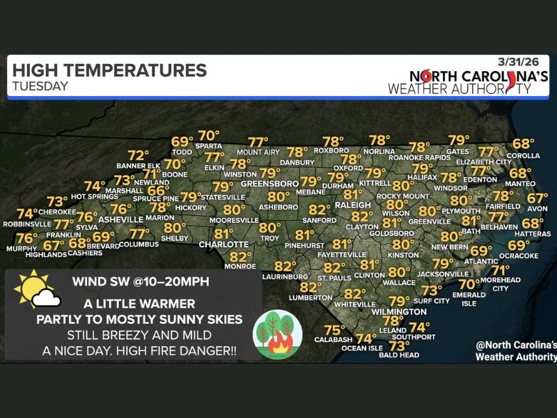
The final day of March is expected to feel more like early May, with widespread sunshine and only a minimal chance of isolated showers.
Temperatures Climb Into 70s and 80s Across the State
Forecast data shows a broad warming trend across nearly all of North Carolina, with most cities experiencing above-average temperatures.
Central and eastern areas are expected to be the warmest:
- Raleigh around 81 degrees
- Durham near 79 degrees
- Greenville and Wilson reaching 80 degrees
- Fayetteville climbing to 81 degrees
In the Piedmont and western regions:
- Charlotte near 81 degrees
- Greensboro around 79 degrees
- Asheboro reaching 80 degrees
Mountain areas remain slightly cooler but still mild:
- Boone near 70 degrees
- Banner Elk around 72 degrees
- Asheville in the mid-70s
Even coastal communities are expected to stay warm, with highs generally in the upper 70s to near 80 degrees, including areas like Wilmington and New Bern.
Breezy Winds Add to Fire Risk Concerns
While the warm temperatures will dominate headlines, wind conditions are another key factor today.
Southwest winds are expected to range between 10 and 20 mph, creating a breezy environment across the state. Combined with dry conditions and low humidity, this setup significantly increases the risk of fire spread.
Officials are urging residents to take precautions, including:
- Properly disposing of cigarettes and matches
- Avoiding activities that could create sparks
- Keeping vehicles off dry grass and leaves
Dry vegetation across much of the state can ignite quickly under these conditions.
Mostly Sunny Skies With Limited Rain Chances
Skies across North Carolina will remain partly to mostly sunny, helping temperatures climb efficiently through the day.
Rain chances are extremely limited, with only a slight possibility of an isolated shower. Most areas — nearly the entire state — are expected to stay dry. This lack of moisture further contributes to the elevated fire danger.
A Warm but Potentially Hazardous Spring Day
Although the weather will feel pleasant and spring-like, the combination of warmth, wind, and dry conditions creates a more hazardous environment than it may appear.
Residents are encouraged to enjoy the sunshine but remain mindful of fire safety, especially during the afternoon when temperatures and winds peak.
Warm Pattern Continues With Fire Danger in Focus
The overall setup points to a warm, sunny, and breezy day across North Carolina, with temperatures well above seasonal averages and fire danger remaining high.
Conditions will continue to be monitored as this warm and dry pattern persists across the state. Stay with NapervilleLocal.com for continued weather updates and statewide coverage.

I’ve lived in Naperville long enough to see how quickly our community changes — from new developments downtown to sudden shifts in our Midwest weather. Reporting on Naperville news and daily forecasts gives me the chance to keep neighbors informed about what really matters. My goal is simple: deliver clear, timely updates so you always know what’s happening in our city and what to expect from the skies above.