
Vermont, New Hampshire and Maine Face Heavy Rain Flood Risk and Northern Snow Accumulation With 2 Plus Inches Possible Into Wednesday
MONTPELIER, VERMONT — A complex weather system is bringing a mix of heavy rain and accumulating snow across parts of New England, with central Vermont, New Hampshire, and western Maine facing the greatest risk for flooding and wintry impacts through Wednesday morning.
The system is expected to persist through multiple rounds of precipitation, increasing concerns for both rising water levels and snow accumulation in northern areas.
Heavy Rain Targets Central Vermont Into New Hampshire
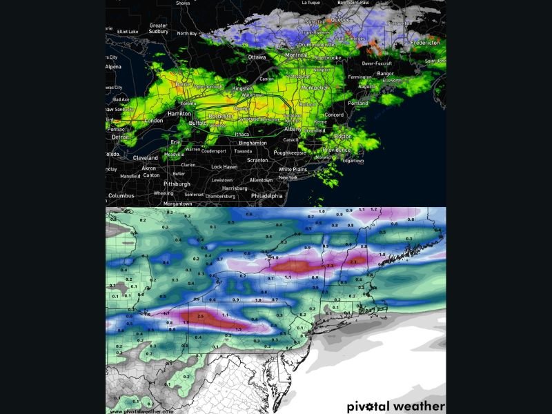
Radar trends show a steady push of heavy rain moving into central portions of Vermont, extending eastward into New Hampshire and parts of western Maine.
Rainfall totals could exceed:
- 2 inches or more across central Vermont
- Similar totals spreading into New Hampshire and western Maine
This amount of rainfall, especially over a short period, raises the potential for localized flooding, particularly in areas where rivers and streams are already running high.
Flooding Concerns Increase With Repeated Rain Bands
The pattern includes multiple waves of precipitation:
- Initial heavy rain through the morning and early afternoon
- A brief lull
- Another round of rain arriving later in the evening
This repeated rainfall could lead to:
- Rising creeks and small rivers
- Water pooling in low-lying areas
- Rapid changes in water levels in vulnerable locations
Residents are advised to monitor nearby waterways closely, especially if conditions begin to worsen quickly.
Snow Accumulation Expected Across Northern Areas
While rain dominates central and southern areas, colder air to the north is supporting snow accumulation across northern New England.
Higher elevations and northern locations such as:
- Northern Maine, including areas near Allagash and Moosehead
- Parts of northern New Hampshire
- Elevated regions near Mount Washington
could see accumulating snow in the 2 to 8 inch range, with locally higher totals possible in the most elevated terrain.
Mixed Weather Pattern Creates Sharp Regional Differences
This system highlights a sharp divide in weather conditions across the region:
- Rain and flood risk in central and southern zones
- Snow accumulation in northern and higher elevation areas
Cities such as Boston, Hartford, and Providence are expected to remain primarily in the rain zone, while northern communities experience more wintry conditions.
What Residents Should Watch For
With both rain and snow impacting the region, residents should be prepared for:
- Rapid water level rises in streams and rivers
- Slushy or snow-covered roads in northern areas
- Reduced visibility during heavier precipitation
Even without widespread warnings currently in place, conditions can change quickly as the system evolves.
Active Weather Continues Into Wednesday Morning
The system is expected to continue through early Wednesday before gradually tapering off. However, lingering impacts such as high water levels and snow-covered surfaces may persist beyond the main event.
Residents across Vermont, New Hampshire, and Maine are encouraged to stay alert and monitor local conditions as this evolving weather system moves through New England. Stay with NapervilleLocal.com for continued updates on this developing weather situation.

I’ve lived in Naperville long enough to see how quickly our community changes — from new developments downtown to sudden shifts in our Midwest weather. Reporting on Naperville news and daily forecasts gives me the chance to keep neighbors informed about what really matters. My goal is simple: deliver clear, timely updates so you always know what’s happening in our city and what to expect from the skies above.