
Texas, Oklahoma Night Storm Line Targets Abilene, Wichita Falls, Lawton and Dallas-Fort Worth With Hail, 65 MPH Winds and Isolated Tornado Risk
WICHITA FALLS, TEXAS — A developing line of strong to severe thunderstorms is expected to sweep across parts of Texas and Oklahoma tonight, bringing the threat of large hail, damaging winds, isolated tornadoes, and heavy rainfall as it moves east toward the Dallas-Fort Worth metroplex.
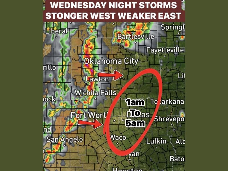
Storms are forecast to organize west of Abilene, Wichita Falls, and western Oklahoma, where conditions will support the strongest activity before gradually weakening overnight.
Strongest Storms Expected West of I-35
The most intense storms are expected to develop in areas west of I-35, particularly near Abilene, Lawton, and Wichita Falls, where instability and wind energy will be highest.
These storms could produce large to very large hail, wind gusts up to 65 mph, and a low but notable tornado risk, especially during the early stages of storm development. Heavy rainfall may also accompany these storms, leading to brief localized flooding in some areas.
Storm Line Moves Toward Dallas-Fort Worth Overnight
As the storm line pushes east, it is expected to begin weakening as it approaches the Dallas-Fort Worth metroplex around midnight.
However, even weakening storms could still bring periods of heavy rain and gusty winds into areas including Fort Worth, Dallas, and Waco. The primary window for impacts across the metroplex is expected between 1 AM and 5 AM, when storms pass through the region.
Weaker Storms East of I-35 but Still a Risk
Communities east of I-35, including areas stretching toward Texarkana and parts of eastern Texas, will likely see weaker storms overall.
Despite this, there remains a marginal risk of isolated severe storms, meaning a few stronger cells could still produce gusty winds or brief heavy downpours. Residents should not completely let their guard down, especially during overnight hours when storms can be harder to track.
Overnight Timing Could Increase Impact Risk
The overnight timing of these storms adds another layer of concern, as many residents will be asleep when the strongest storms move through.
Quick-moving storms combined with reduced visibility and nighttime conditions can make severe weather more dangerous. Emergency alerts and weather notifications should be enabled to ensure timely warnings.
Final Outlook
A line of storms will track from western Texas and Oklahoma into the Dallas-Fort Worth region overnight, bringing a range of severe weather threats before gradually weakening toward morning.
Areas west of I-35 face the highest risk, while locations east—including parts of eastern Texas—may still see isolated impacts. Stay with NapervilleLocal.com for continued updates as this overnight storm system develops.

I’ve lived in Naperville long enough to see how quickly our community changes — from new developments downtown to sudden shifts in our Midwest weather. Reporting on Naperville news and daily forecasts gives me the chance to keep neighbors informed about what really matters. My goal is simple: deliver clear, timely updates so you always know what’s happening in our city and what to expect from the skies above.