
3 PM to 9 PM: Strong Storm Risk Builds After Morning Rain Across the Illinois With Wind and Tornado Threat Potential
ILLINOIS — A wet and unsettled start to Thursday is expected to transition into a more concerning weather pattern later in the day, as early rain and thunderstorms give way to a warmer, more unstable atmosphere capable of producing stronger storms. While the morning hours bring mainly heavy rain with limited severe risk, conditions are forecast to shift significantly by afternoon and evening, increasing the potential for damaging weather impacts.
Morning Hours Bring Widespread Rain and Thunderstorms
The day begins with numerous showers and thunderstorms moving across the region through the morning hours. These storms are expected to be efficient rain producers, with periods of heavy rainfall likely.
While a few storms may produce gusty winds or small hail, the overall severe weather threat during the morning remains low. Breaks in rainfall are possible, but conditions will stay unsettled through late morning.
Residents heading out early are advised to keep umbrellas handy, as intermittent rain will continue through midday.
Afternoon Transition Creates Higher Storm Potential
As the day progresses, a noticeable shift in conditions is expected. Temperatures will rise quickly, climbing from the upper 30s in the early morning to near 70°F by the evening. Along with this warming trend, humidity levels will increase, creating a more unstable atmosphere.
Any sunshine that develops will further enhance instability, setting the stage for stronger storms to develop later in the day. Storm development during the afternoon and evening is considered highly likely, though the exact intensity remains uncertain.
Severe Weather Risk Peaks Between 3 PM and 9 PM
The most critical window for potentially severe weather appears to be between 3:00 PM and 9:00 PM.
If storms strengthen as expected, multiple hazards could come into play:
- Primary threat: Damaging wind gusts
- Secondary threat: Tornado potential
- Additional threat: Hail
While forecasters emphasize that severe weather is not guaranteed, the environment may support intense storms if all conditions align correctly. This includes the possibility of isolated tornadoes and very strong wind events.
Conditions Not Guaranteed, But Risk Is Present
It is important to note that this is not a guaranteed severe weather event, but rather a situation where the ingredients could come together quickly. The uncertainty lies in how much instability develops and how storms organize later in the day.
Residents are encouraged to remain alert but not alarmed. Having multiple ways to receive weather warnings will be important, especially during the evening hours when storms could intensify.
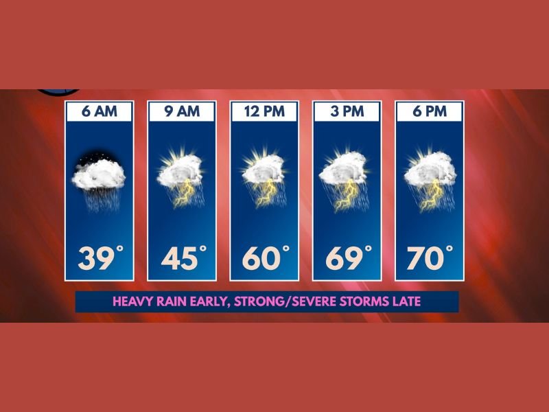
Temperature and Timing Breakdown
- 6 AM: Rain, around 39°F
- 9 AM: Thunderstorms begin, around 45°F
- 12 PM: Storms continue, near 60°F
- 3 PM: Stronger storms possible, around 69°F
- 6 PM: Continued storm risk, near 70°F
The overall trend clearly shows a shift from cool, rainy conditions to warm, unstable weather—fueling the increased storm threat later in the day. Stay with NapervilleLocal.com for the latest weather updates and local forecast coverage.

I’ve lived in Naperville long enough to see how quickly our community changes — from new developments downtown to sudden shifts in our Midwest weather. Reporting on Naperville news and daily forecasts gives me the chance to keep neighbors informed about what really matters. My goal is simple: deliver clear, timely updates so you always know what’s happening in our city and what to expect from the skies above.