
After 2 PM: Severe Storm Risk Develops Across Michigan With Damaging Winds, Tornadoes and Mixed Precipitation Statewide
MICHIGAN — A complex and active weather day is unfolding across the state as multiple types of precipitation combine with rising temperatures and strengthening winds. From snow and ice in the north to warm, storm-driven conditions in the south, the biggest concern arrives later today as severe storms become possible, especially after the afternoon hours.
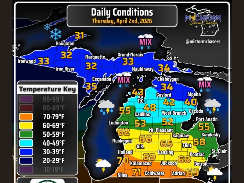
Northern Michigan Sees Snow, Ice and Rain Mix
Across the Upper Peninsula and northern parts of the Lower Peninsula, conditions remain wintry through much of the day.
Snow is expected early, gradually transitioning to ice and then rain. Areas in the northern Lower Peninsula may experience freezing rain and sleet before changing over to rain, with ice accumulations generally staying below 0.3 inches.
Temperatures in these regions range from the low 30s, keeping conditions slick and hazardous, especially during the morning hours.
Rainfall and Strong Winds Impact Multiple Regions
Rain becomes a widespread factor across much of the state, with the heaviest totals expected in northwestern portions of the Lower Peninsula, where rainfall could exceed 1.5 inches.
Wind gusts will also be a major factor throughout the day, reaching 15 to 25 mph statewide, with localized gusts up to 35 mph, particularly across the Upper Peninsula.
These winds, combined with ongoing precipitation, may create reduced visibility and difficult travel conditions.
Southern Michigan Warms Up Ahead of Severe Storm Threat
Conditions shift significantly further south, where temperatures climb into the upper 60s and low 70s by the afternoon.
This warming trend helps fuel atmospheric instability, setting the stage for potential severe weather development later in the day, especially across southern and southwestern parts of the state.
Severe Weather Risk Increases After 2 PM
The primary window for severe storms begins after 2:00 PM EDT, with the greatest focus on western and southwestern Lower Michigan.
If storms intensify, the following hazards are possible:
- Damaging winds up to 60 mph
- A few tornadoes
- Large hail up to 1 inch in diameter
While the setup supports severe weather, earlier-day showers and storms could influence how strong later storms become. The situation remains conditional but concerning.
Storm Activity Expected to End Overnight
Severe weather risks are expected to gradually decrease later in the night, with storms likely wrapping up before 2:00 AM EDT.
By that time, much of the state should see improving conditions as the system moves out.
Temperature Overview Across the State
- Upper Peninsula: Low 30s with snow and mixed precipitation
- Northern Lower Peninsula: 30s to low 40s with ice, sleet, and rain
- Central Lower Peninsula: 40s to 50s with steady rain
- Southern Michigan: Upper 60s to low 70s with storm potential
This sharp contrast in temperatures highlights the dynamic nature of today’s weather across Michigan. Stay with NapervilleLocal.com for the latest weather updates and local forecast coverage.

I’ve lived in Naperville long enough to see how quickly our community changes — from new developments downtown to sudden shifts in our Midwest weather. Reporting on Naperville news and daily forecasts gives me the chance to keep neighbors informed about what really matters. My goal is simple: deliver clear, timely updates so you always know what’s happening in our city and what to expect from the skies above.