
After 9 PM: Strong Storms Develop Across Southern Michigan While Upper Peninsula Stays in 30s With Freezing Rain Risk
MICHIGAN — A sharp contrast in weather conditions is expected across the state today, with cold temperatures and wintry conditions in the north and much warmer air in the south. While most of the day remains relatively quiet, attention turns to late evening when storms begin to develop across southern areas.
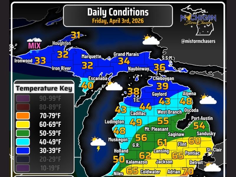
Upper Peninsula Stays Cold With Wintry Mix
Across the Upper Peninsula, temperatures will remain in the low to mid-30s throughout the day.
Conditions will include:
- Snow and mixed precipitation early
- Transition to freezing rain in some areas
- Travel concerns developing into Saturday morning
These colder conditions will keep much of the region locked in a wintry pattern.
Central Areas See Cooler but Improving Conditions
Moving into central parts of the state, temperatures rise into the 40s and 50s, creating a transition zone between cold northern air and warmer southern conditions. Skies will be partly cloudy, with relatively quiet weather through most of the day.
Southern Michigan Warms Near 70 Degrees
Southern parts of the state will experience a much warmer pattern, with temperatures climbing into the 60s and near 70°F, especially in far southwestern areas.
This creates a significant temperature swing of nearly 40 degrees from north to south across the state.
Storms Develop Late Evening After 9 PM
Storm activity is expected to begin after 9:00 PM EDT, primarily across extreme southern Michigan. Some storms may become strong to severe, especially along areas near US-12, where conditions are more favorable for storm development.
Conditions Shift Overnight Into Saturday
As the night progresses, storms continue moving through southern areas while colder, wintry conditions persist in the north. Freezing rain concerns will continue across the Upper Peninsula into Saturday morning, potentially impacting travel.
Mixed Weather Pattern Defines the Day
Today’s weather highlights a split pattern across Michigan, with winter-like conditions in the north and spring-like warmth in the south, followed by late-day storm development in southern regions. Stay with NapervilleLocal.com for the latest weather updates and local forecast coverage.

I’ve lived in Naperville long enough to see how quickly our community changes — from new developments downtown to sudden shifts in our Midwest weather. Reporting on Naperville news and daily forecasts gives me the chance to keep neighbors informed about what really matters. My goal is simple: deliver clear, timely updates so you always know what’s happening in our city and what to expect from the skies above.