
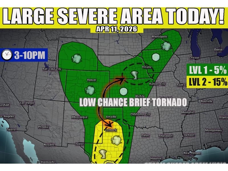
Saturday: Large Severe Weather Area Active From Wisconsin and Wyoming to Texas Between 3–10 PM With Hail, Gusty Winds, and a Low-Chance Brief Tornado Possible
LUBBOCK, Texas — A large but disorganized severe weather area is in play today across a massive stretch of the central United States, spanning from west Wisconsin and Wyoming all the way down to the Big Bend region of Texas. While the setup covers an enormous geographic footprint, forecasters are clear that this will not be a major outbreak scenario — most storms will remain below severe limits and stay sloppy and disorganized through the 3 to 10 PM window. However, a few stronger cores, particularly across west Texas, could produce meaningful hail and gusty winds.
Large Severe Area Active 3 to 10 PM — But Not a Major Outbreak
The severe weather threat is active from mid-afternoon through the evening hours, with the primary window running between 3 PM and 10 PM across the affected zone. Despite the large size of the risk area, the overall character of today’s storm activity is expected to be disorganized and scattered rather than concentrated and intense.
Most storms will remain below the threshold needed to be classified as severe. A Level 1 risk carrying a 5% probability covers the broader zone, while a Level 2 risk at 15% is in place for the more focused area across west Texas where storm organization and coverage will be notably better.
West Texas Faces the Strongest Storm Potential
The area around west Texas — particularly the Lubbock and Amarillo corridor — stands out as the most concerning zone within today’s large severe area. Better wind shear and atmospheric instability in this region will support slightly more organized storm development compared to areas further north.
Hail up to 2 inches in diameter is possible across southwest Texas, which is significantly larger than the pocket-change-size hail expected in the broader Level 1 zone to the north. A wide open atmospheric cap should allow storms to fire and persist for much of the day across this area, though it will also generally keep the most significant severe weather in check.
Hail and Gusty Winds the Primary Threats Across the Broader Zone
For the majority of the large severe area stretching from Wyoming and Wisconsin southward, the primary hazards will be small hail around pocket-change size and gusty winds associated with a few stronger storm cores. These are the hallmark hazards of a Level 1 severe weather setup — real but limited in scope and intensity.
Communities across Nebraska, Kansas, Oklahoma, Colorado, and the broader plains corridor all fall within the outer edges of the risk zone and could encounter a brief strong storm during the afternoon and evening hours.
Brief Weak Tornado Possible in Two Specific Areas
Tornado potential is considered low across virtually the entire severe weather area today, but forecasters have identified two specific zones carrying a non-zero tornado chance. The first is across southwest Texas near the Lubbock area, where storm organization is best. The second is near a weak surface low developing across Nebraska.
Any tornado that does manage to develop in either of these areas is expected to be brief and weak in nature. Residents in those two highlighted zones should nonetheless remain weather aware and have a plan ready should a tornado warning be issued in their vicinity this evening. Stay with NapervilleLocal.com for the latest weather updates and local forecast coverage.

I’ve lived in Naperville long enough to see how quickly our community changes — from new developments downtown to sudden shifts in our Midwest weather. Reporting on Naperville news and daily forecasts gives me the chance to keep neighbors informed about what really matters. My goal is simple: deliver clear, timely updates so you always know what’s happening in our city and what to expect from the skies above.