
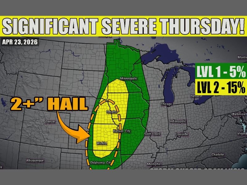
Significant Severe Weather and 2-Inch Plus Hail Targeting Southern Minnesota, Kansas, and Oklahoma Thursday April 23 With Supercells and Overnight Wind Threat Developing
SOUTHERN MINNESOTA, KANSAS, AND OKLAHOMA — A significant severe weather day is shaping up for Thursday April 23, 2026 across a corridor stretching from southern Minnesota through Kansas and into Oklahoma. Supercells producing very large hail over 2 inches are expected to be the dominant storm mode during the daytime hours, with the potential for an overnight wind bag mode to evolve as storms organize into a squall line through the evening. A tornado threat also exists but is expected to remain more isolated and random given the current wind shear vectors in place.
Core Hail Threat Centered From Omaha Through Wichita to Oklahoma City
The 2-plus inch hail threat is concentrated within a dashed oval on the outlook map centered across the most unstable corridor from Omaha southward through Kansas City, Wichita, and into Oklahoma City. This zone carries the highest probability of very large to giant hail with the supercell phase of Thursday’s storm activity during the afternoon and early evening hours.
The broader Level 2 risk zone at 15% probability extends outward from this core to cover a wider area including Minneapolis, Des Moines, and surrounding communities, while a Level 1 zone at 5% covers the full extent of the outlined severe weather area across the region.
Supercells Drive the Daytime Threat Before Overnight Wind Mode
Thursday’s storm evolution is expected to follow a two-phase pattern. During the daytime hours, discrete supercells will be the primary storm mode across the Plains, capable of producing the very large hail highlighted in the outlook alongside an isolated tornado threat that cannot be entirely dismissed despite the less favorable shear setup.
As the evening progresses, storms are expected to consolidate and transition into a more linear squall line configuration, potentially producing a widespread damaging wind threat across a broad corridor overnight. The overnight wind bag mode would extend the severe weather threat well beyond the initial daytime supercell activity.
Tornado Potential Exists but Remains More Isolated
While Thursday’s setup is primarily a hail and wind event, a tornado threat is present across the risk corridor. Wind shear vectors may keep tornado development more isolated and random compared to more classic tornado outbreak setups, but the possibility cannot be completely ruled out with the supercell activity expected during the afternoon hours.
Storm chasers and meteorologists will be monitoring the evolution of the wind shear profile closely through Thursday morning and afternoon for any signs that the tornado potential is trending higher than currently anticipated.
Prepare for Both Daytime and Overnight Severe Weather
The two-phase nature of Thursday’s threat means residents across the risk corridor need to be prepared not just for the afternoon supercell window but also for the potential overnight squall line and wind threat. Have multiple ways to receive weather alerts active through the overnight hours and ensure shelter plans are ready for both the daytime and overnight phases of Thursday’s significant severe weather setup. Stay with NapervilleLocal.com for the latest weather updates and local forecast coverage.

I’ve lived in Naperville long enough to see how quickly our community changes — from new developments downtown to sudden shifts in our Midwest weather. Reporting on Naperville news and daily forecasts gives me the chance to keep neighbors informed about what really matters. My goal is simple: deliver clear, timely updates so you always know what’s happening in our city and what to expect from the skies above.