
EF3+ Long-Track Tornadoes, Very Large Hail, and Damaging Winds Targeting Illinois Including Rockford, Chicago, and Springfield Monday Afternoon Into Monday Night
ILLINOIS — A severe weather and tornado outbreak is possible across Illinois Monday afternoon into Monday night, carrying the highest ceiling of the season so far for significant hazards across the state. Damaging wind gusts, very large hail, and long-tracked intense tornadoes rated EF-3 or stronger are all on the table, with the environment from northwest Illinois down through southern Illinois described as extremely favorable for strong and long-track tornado development Monday afternoon through the evening hours.
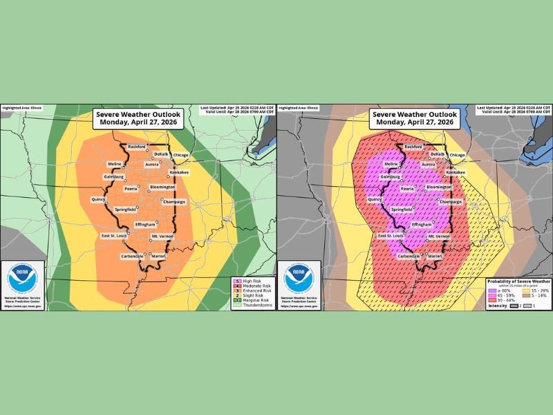
Highest Tornado Confidence Across Pink Zone Covering Central Illinois
The highest confidence for intense storm activity sits within the pink outlined zone covering a large swath of central and northern Illinois including Rockford, DeKalb, Moline, Galesburg, Peoria, Bloomington, Champaign, Springfield, Effingham, and Mount Vernon. This corridor represents the area where the atmospheric environment is most favorable for significant and long-track tornadoes from Monday afternoon onward.
Forecasters have noted lower confidence across far northern Illinois and the Chicagoland area, where morning and afternoon convection could hold back the overall moisture and instability needed to fuel the most intense storm activity. Further south and west across northwest Illinois down into southern Illinois, however, conditions are described as possible to likely for strong long-track tornadoes during the Monday afternoon and evening window.
Storms Transition to QLCS Tornado Threat After Dark
As the system progresses through the evening, storms are expected to transition into a quasi-linear convective system tornado threat after dark Monday night as the line pushes east across Illinois into Indiana. This means the tornado threat does not end with sunset, and communities across eastern Illinois and Indiana should remain weather-aware well into the overnight hours.
Outlook upgrades are expected as the event draws closer. With the setup still more than 48 hours out at the time of this outlook, shifts in the threat area remain very much possible and forecasters will be updating the outlook numerous times through the weekend and into Monday.
Plans Monday Afternoon and Evening Need a Weather Safety Component
Anyone with outdoor plans or travel scheduled Monday afternoon into Monday night across Illinois needs to keep this severe weather threat front of mind. Ensure a safe shelter location is identified well in advance, have a disaster kit prepared, and keep multiple weather alert systems active throughout the full duration of the event as this potentially significant outbreak continues to come into sharper focus heading into the new week. Stay with NapervilleLocal.com for the latest weather updates and local forecast coverage.

I’ve lived in Naperville long enough to see how quickly our community changes — from new developments downtown to sudden shifts in our Midwest weather. Reporting on Naperville news and daily forecasts gives me the chance to keep neighbors informed about what really matters. My goal is simple: deliver clear, timely updates so you always know what’s happening in our city and what to expect from the skies above.