
Individual Rotating Storms With Strong Long-Track Tornadoes Threatening Iowa, Illinois, and Missouri Under Level 3 Enhanced Risk Monday Afternoon Into Monday Night
IOWA, ILLINOIS, AND MISSOURI — A widespread weather system is expected to bring intense thunderstorms to the middle Mississippi, Ohio, and Tennessee Valleys this Monday, April 27, with the highest risk centered across Iowa, Illinois, and Missouri under a Level 3 out of 5 Enhanced Risk designation. Individual rotating storms are likely to form early in the afternoon carrying the highest risk for producing strong and long-track tornadoes, before merging into a larger line or cluster as the evening progresses and the system moves southeast.
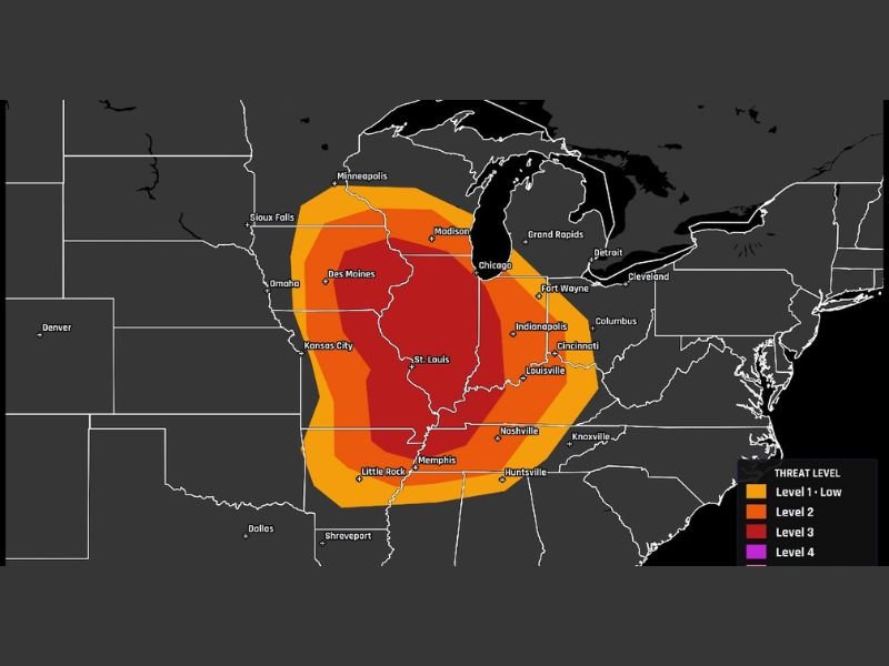
Rotating Supercells Most Likely Early Afternoon Across Iowa, Illinois, and Missouri
The most dangerous window of the event comes early in the afternoon when individual rotating storms are expected to develop across the core threat zone. These discrete supercells carry the highest potential for producing strong and long-track tornadoes, particularly across Iowa, Illinois, and Missouri where the Level 3 Enhanced Risk core sits. Cities including Des Moines, Chicago, St. Louis, Kansas City, and Indianapolis all fall within the elevated threat footprint on Monday’s outlook map.
As the evening progresses, these individual storms will likely consolidate into a larger line or cluster moving southeast, shifting the primary threat toward damaging straight-line winds while the tornado risk continues in a linear storm mode after dark.
Level 3 Core Covers Illinois With Broader Threat Into Indiana and Kentucky
The Level 3 Enhanced Risk zone covers a large and densely populated corridor with Illinois sitting at the heart of the highest concern area. The broader threat extends outward across a wide orange zone reaching from Des Moines and Omaha in the west through Fort Wayne, Indianapolis, Cincinnati, Louisville, and Nashville to the east and southeast.
Memphis, Little Rock, and Huntsville also fall within the elevated risk footprint, underscoring the enormous geographic scope of Monday’s severe weather setup across the middle Mississippi, Ohio, and Tennessee Valley regions.
Monday Plans Across the Entire Region Need a Weather Safety Component
With the Level 3 Enhanced Risk covering some of the most densely populated metro areas in the Midwest including Chicago, St. Louis, Indianapolis, and Cincinnati, the potential impact of Monday’s severe weather event is significant.
Residents across the full outlined threat zone should identify a safe shelter location well in advance, prepare a disaster kit, and keep weather alert systems active throughout Monday afternoon and into the overnight hours as the storm system progresses southeast. Stay with NapervilleLocal.com for the latest weather updates and local forecast coverage.

I’ve lived in Naperville long enough to see how quickly our community changes — from new developments downtown to sudden shifts in our Midwest weather. Reporting on Naperville news and daily forecasts gives me the chance to keep neighbors informed about what really matters. My goal is simple: deliver clear, timely updates so you always know what’s happening in our city and what to expect from the skies above.