
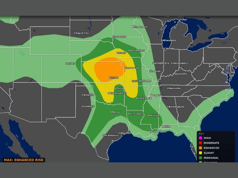
Very Large Hail, Damaging Winds, and Strong Tornadoes Threatening Central and Southern Plains Including Wichita, Oklahoma City, Kansas City, and Tulsa With Enhanced Risk in Place Today
CENTRAL AND SOUTHERN PLAINS — A dangerous severe weather day is underway across the Central and Southern Plains today, Sunday, April 26, 2026, with very large hail, damaging winds, and a few strong tornadoes all on the table. The Storm Prediction Center’s categorical outlook places an Enhanced Risk covering a broad corridor from the Oklahoma City and Tulsa area northward through Wichita and into the Kansas City and Omaha region. Millions of residents across Kansas, Oklahoma, Nebraska, and Missouri are in the direct path of today’s severe weather threat.
Enhanced Risk Core Centered on Kansas and Oklahoma With Moderate Zone Possible
The highest concentration of severe weather potential sits across central Kansas and northern Oklahoma, where an Enhanced Risk — Level 3 on the SPC scale — encompasses cities including Wichita, Tulsa, and Oklahoma City. A Moderate Risk signature is embedded within this area, indicating the potential for particularly intense or widespread severe weather activity during the afternoon and evening hours.
The threat axis extends northward into the Omaha and Des Moines corridors under a Slight Risk, while areas farther east including St. Louis, Springfield Missouri, and Little Rock fall within Marginal coverage. Even areas outside the Enhanced zone should remain alert throughout the day.
Very Large Hail and Damaging Winds Are Primary Hazards Alongside Tornado Threat
Supercell thunderstorms capable of producing very large hail and widespread damaging winds are the primary drivers of today’s Enhanced Risk designation. Hail events of significant size can cause major damage to vehicles, rooftops, and crops with little warning, making shelter indoors the only safe option when storms approach.
Damaging straight-line winds associated with storm clusters or squall lines are also a significant concern, particularly as storm systems evolve through the afternoon. Wind damage can extend well ahead of the most intense storm cores, catching residents off guard in areas outside tornado warning zones.
Strong Tornadoes Possible Within Enhanced and Moderate Risk Zones This Afternoon
A few strong tornadoes are possible today, particularly within the Enhanced and embedded Moderate Risk areas across Kansas and Oklahoma. Tornado-producing supercells are most likely during peak heating hours in the afternoon, though the threat can persist into the evening as the storm system continues to push eastward.
Residents in Wichita, Oklahoma City, Tulsa, Kansas City, and surrounding communities should have a shelter plan in place before storms develop. Do not wait for a tornado warning to begin moving toward a safe location.
Broad Severe Weather Footprint Stretches From Gulf Coast to Upper Midwest Today
The overall severe weather footprint today is expansive, with Thunder and Marginal Risk zones stretching from the Gulf Coast near Houston and New Orleans northward to Minneapolis and across much of the Southeast. This broad coverage means storm activity could impact a wide range of communities even outside the most intense risk areas.
Anyone with outdoor plans today across the Central or Southern Plains should monitor conditions closely and be prepared to take shelter quickly if warnings are issued in their area. Stay with NapervilleLocal.com for the latest weather updates and local forecast coverage.

I’ve lived in Naperville long enough to see how quickly our community changes — from new developments downtown to sudden shifts in our Midwest weather. Reporting on Naperville news and daily forecasts gives me the chance to keep neighbors informed about what really matters. My goal is simple: deliver clear, timely updates so you always know what’s happening in our city and what to expect from the skies above.