
Damaging Wind Gusts, Hail, Tornado and 1 to 4 Inches of Rain Targeting Georgia Including Atlanta, Rome and Gainesville Wednesday Afternoon Through Thursday Morning Under Level 2 Threat
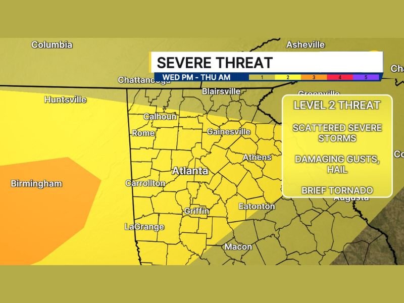
GEORGIA — A Level 2 severe weather threat has been upgraded for Wednesday afternoon through Thursday morning, May 6 to 7, 2026, across Georgia with scattered severe storms expected to impact Atlanta, Rome, Gainesville, Carrollton, and surrounding communities.
Damaging wind gusts are the primary hazard, with large hail and a brief tornado also possible through the evening hours. Rainfall of 1 to 2 inches is expected broadly with isolated totals of 3 to 4 inches capable of causing flooding across smaller rivers, streams, creeks, and urban areas despite the ongoing drought.
Damaging Wind Gusts Headline the Wednesday Afternoon and Evening Severe Threat
Damaging wind gusts are identified as the main threat across the Level 2 zone covering metro Atlanta and the broader north and central Georgia corridor through Wednesday night. The severe threat window opens late this afternoon and continues through Thursday morning.
Rome, Calhoun, Gainesville, Athens, Carrollton, Griffin, LaGrange, and Eatonton all fall inside the active severe weather zone through the overnight hours.
Large Hail and Brief Tornado Possible With Scattered Severe Storms Wednesday
Large hail and a brief tornado are both possible as scattered severe storms develop and move through the Georgia risk zone during the Wednesday evening hours. While damaging winds carry the highest confidence, any storm organizing within the risk zone could produce multiple hazards simultaneously.
Residents across Atlanta and surrounding communities should have weather alerts active and shelter plans identified before storms arrive this afternoon.
Isolated 3 to 4 Inch Rainfall Totals Could Cause Flooding Despite Ongoing Drought
Rainfall totals of 1 to 2 inches are expected across the broader area, with isolated pockets reaching 3 to 4 inches. Even amid ongoing drought conditions, rainfall at these rates in a short period can overwhelm smaller waterways and cause urban flooding across low-lying streets and drainage systems.
Residents should avoid driving through flooded roadways and monitor local water levels through Thursday morning as the system exits the region. Stay with NapervilleLocal.com for the latest weather updates and local forecast coverage.

I’ve lived in Naperville long enough to see how quickly our community changes — from new developments downtown to sudden shifts in our Midwest weather. Reporting on Naperville news and daily forecasts gives me the chance to keep neighbors informed about what really matters. My goal is simple: deliver clear, timely updates so you always know what’s happening in our city and what to expect from the skies above.