
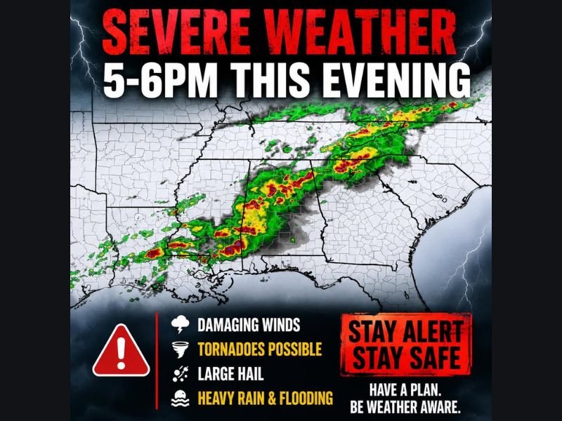
Damaging Winds, Tornadoes, Large Hail and Heavy Rain Targeting the Gulf Coast Tonight Beginning 5 to 6PM With Overnight Severe Weather Continuing Into the Early Morning Hours
GULF COAST — A serious and overnight severe weather threat is rolling through the Gulf Coast this evening and continuing into the overnight hours, Wednesday May 6, 2026, with the active window beginning between 5 and 6 PM. Damaging winds, tornadoes, large hail, and heavy rain with flooding are all confirmed hazards for tonight across the Gulf Coast region. Radar is already showing intense red and orange returns across a broad line of storms stretching from Mississippi through Louisiana and into the coastal zones, making tonight a genuine overnight emergency weather situation for millions of residents.
Damaging Winds and Tornadoes Possible as Severe Line Pushes Through Tonight
Damaging winds are the primary hazard with tonight’s storm line as it pushes through the Gulf Coast region between 5 PM and through the overnight hours. Tornadoes are also possible with any rotating cells embedded within the line during the evening and overnight window.
The storm line visible on radar shows intense cores already organized and moving through the region, with the most dangerous activity expected during the evening hours before transitioning into a prolonged overnight severe weather event.
Large Hail and Heavy Rain With Flooding Accompany the Evening Storm Line
Large hail and heavy rainfall capable of producing flooding round out the hazard profile for tonight across the Gulf Coast. The combination of all four hazards simultaneously makes tonight’s setup one that demands serious attention and advance preparation from all residents in the path of the storm line.
Phone charges should be completed now, weather alerts must be active on all devices, and multiple ways to receive warnings should be established before the 5 to 6 PM storm arrival window.
Residents Urged to Have Clothes and Shelter Plan Ready Before Going to Sleep Tonight
Given the overnight nature of tonight’s severe weather threat, residents across the Gulf Coast are strongly urged to have clothes within arm’s reach, shelter locations identified inside the home, and weather alert systems active before going to sleep. Tornado warnings overnight require immediate action with no time to spare locating shelter or proper clothing in the dark. Stay with NapervilleLocal.com for the latest weather updates and local forecast coverage.

I’ve lived in Naperville long enough to see how quickly our community changes — from new developments downtown to sudden shifts in our Midwest weather. Reporting on Naperville news and daily forecasts gives me the chance to keep neighbors informed about what really matters. My goal is simple: deliver clear, timely updates so you always know what’s happening in our city and what to expect from the skies above.